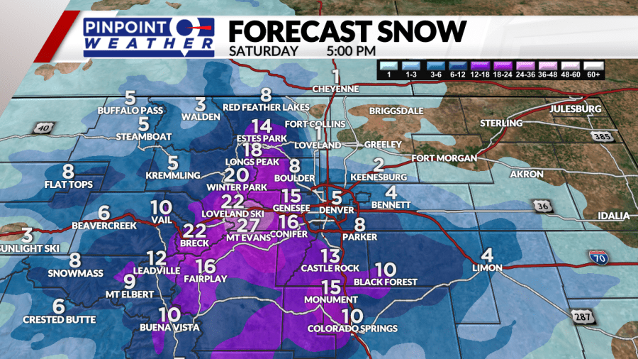
DENVER (KDVR) — Denver, along with most of Colorado, is preparing for a winter storm that has the potential to drop upwards of 2 feet of snow in some places, and enough on the Front Range to have significant impacts Friday night into Saturday morning.
According to the Pinpoint Weather Team, there will be a total of about 1.5 inches of liquid equivalent in this storm. How much of it falls as snow depends largely on what the temperature will be as it comes down.
How temperature impacts snowfall totals
In Denver, the storm is expected to start as rain late Friday morning when temperatures will be in the low 40s. Throughout the day temperatures will slowly cool off and the turnover to snow is expected around 6 or 7 p.m. Temperatures get to freezing around midnight, and remain there until about 7 a.m. Saturday. The precipitation may change back to rain before ending around 10 a.m.
The Pinpoint Weather Team is forecasting between 1-4 inches for Denver and the Front Range.
However, temperatures in Idaho Springs will already be near freezing when the storm starts Friday morning, and drop into the 20s through the day and into the night. These colder temperatures mean any moisture that falls will be snow. It will also begin sticking to the ground faster because it will not have as much of a chance to warm up beforehand.
The Pinpoint Weather Team is forecasting up to 2 feet of snow for Idaho Springs and the foothills.

From red flags to winter storms
One of the unique aspects of this storm is that it comes late in May, specifically after several dry months that have had many parts of the Front Range under frequent red flag warnings for several weeks.
The high temperature in Denver is forecast to be 90 degrees Thursday. But a swing of more than 50 degrees will have temperatures at or near freezing by late Friday night.
The National Weather Service issued a red flag warning for most of eastern Colorado up to the foothills for Thursday. Conditions for the fire weather include high temperatures, low humidity and strong winds.
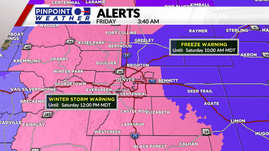
That changes Friday, as temperatures plummet. Denver, along with the Front Range, foothills and as far west as Silverthorne and Kremling are under a winter storm warning. A Winter Weather Advisory has also been issued for the rest of the high country and areas around Limon.

You can read more about the difference between a winter storm watch and a winter storm warning here.
Avalanche danger rises
With the late-season snow ahead, officials are warning of increasing avalanche danger through the weekend in some of Colorado’s mountainous regions.
According to the Colorado Avalanche Information Center, backcountry avalanche dangers for the state’s mountain regions this weekend are as follows:
- Northern Mountains: moderate on Friday, considerable on Saturday
- Central Mountains: low on Friday, moderate on Saturday
- Southern Mountains: low on Friday, low on Saturday
Danger will grow as snow accumulates in the Northern and Central Mountain regions, the CAIC warned.
Denver’s biggest temperature drops
This storm is set to bring a 24-hour temperature drop of 41 degrees to Denver between the afternoon high of 88 degrees Thursday and the afternoon high of 47 degrees on Wednesday.
When looking at a three-day temperature change, Denver’s high of 88 Thursday afternoon will drop 58 degrees to a low of 30 Saturday morning.
Pinpoint Weather Meteorologist Travis Michels looked at how this compares to historic temperature changes.
“All of the top 10 temperature drops (one day, two days, and three days) are all in the winter months, so a swing this far in the spring is notable,” he said.
The most significant three-day drop was 80 degrees in February 1951 when temperatures swung from a high of 73 to a low of minus 7.
More about the historic temperature swings.
Denver’s snowiest Mays and latest snowfalls
While it is unusual for Denver to have snow in the back half of May, it is also not rare. In one year, the last snowfall didn’t even happen until June.
In fact, this year doesn’t even crack the top five latest snowfalls, and ties with half a dozen other years for the No. 6 spot.
#1 June 2, 1951
#2 May 29, 1975
#3 May 28, 1950
— May 28, 1947
#5 May 24, 2002
#6 May 21, 2019
— May 21, 2001
— May 21, 1931
— May 21, 1910
— May 21, 1891
— May 21, 2022 (forecast)
It’s a similar story for the snowiest Mays in the city’s history.
The Pinpoint Weather Team is forecasting 4 inches of snow for Denver, and with this being the only snow we’ve had all month that will likely be the total for the month.
In previous years, May has been much snowier. There have been at least five Mays with a foot of snow or more since record-keeping began.
#1 1898: 15.5 inches
#2 1950: 13.7 inches
#3 1978: 13.5 inches
#4 1912: 13.2 inches
#5 1917: 12 inches
Freeze warning and protecting your plants
Temperatures are expected to drop below freezing in Denver on both Friday and Saturday nights. This means it’s important to take some precautions around your home to protect your belongings and any planting you may have done.
Chief Pinpoint Meteorologist Dave Fraser generally advises waiting until after Mother’s Day to plant any flowers or bushes.
Many people took his advice, and with a few simple steps, anything you have planted in the ground can be protected.
Annuals are at a higher risk than other flowers because they do not establish deep roots. Some popular varieties include petunias, marigolds and geraniums.
Tender vegetables are also at risk since they cannot withstand frost.
“The easiest way to protect them is just to put a large bucket over each,” Erin Bird with Denver Botanic Gardens said.
For larger areas, plants can be protected using sheets or blankets. Do not use plastic coverings, as they will make plants colder.
“Perennials and trees and shrubs are usually hardy enough to withstand a late-season snow or a little bit of frost,” Bird said. In fact, it may even help them thanks to the moisture coming after our recent dry months.
Thankfully, temperatures only dip below freezing for a few hours each night, and even then only by a few degrees. This means sprinklers or anything buried should not be impacted.
More tips about protecting your plants and vegetables here.
As with late snowfall, this late freeze is unusual but not uncommon.
#1 June 8, 2007
#2 June 2, 1951
#3 June 1, 1919
#4 May 30, 1883
#5 May 28, 1947
#6 May 26, 1950
#7 May 24, 2002
#8 May 22, 2019
— May 22, 1930
— May 22, 1910
#11 May 21, 2022 (forecast)
Full Pinpoint Weather coverage
On TV and online, the Pinpoint Weather Team will keep you updated with the latest forecast for Denver and Colorado. Be sure to download the free Pinpoint Weather App to stay up-to-date with the newest data as it comes in. Stayed tuned to FOX31 and Channel 2 for live team coverage throughout the storm.
- Closings & Delays: Full List
- Interactive Radar
- Delays and cancellations at Denver International Airport
Do you have questions about this late-season winter storm? The Pinpoint Meteorologist Team holds frequent Ask a Met segments on FOX31 NOW.
You can submit a question during our live broadcasts, or on Twitter using #AskAMet. Another way to ask your questions is by emailing askamet@digital-staging.kdvr.com.

