DENVER (KDVR) — Snow showers have been reported from the metro areas to the mountains late Tuesday as another system moves through the region to bring travel impact to Colorado, and to slow the melt of the recent snow for the city.
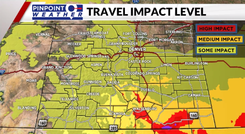
The impact will be highest for those in southern Colorado.
The storm system to move across northern New Mexico will bring snow and wind to extreme southeastern Colorado for the rest of Tuesday night and early Wednesday.
There are various advisories, including a blizzard warning for some of those rural areas.
Some light snow from that same storm system will reach the Front Range and metro Denver. We are expecting the snow through the night with a few lingering flurries very early on Wednesday.
Accumulation for our area looks light with most places receiving less than an inch. So, there should be little impact given that everything is still cold and snow-covered.
We will turn dry with plenty of sunshine from Wednesday afternoon through Saturday. Temperatures will return to the 40s and 50s by the weekend.
Snow will start to melt fast, causing splash back on area roads. Just watch out for freezing of melting snow during the overnight hours, especially on side streets.
We are tracking another storm that will bring rain and snow showers back to Denver on Sunday into Monday. And, another potential shot of snow is possible again next Wednesday.
March is turning out to deliver as Denver’s snowiest month of the year.


