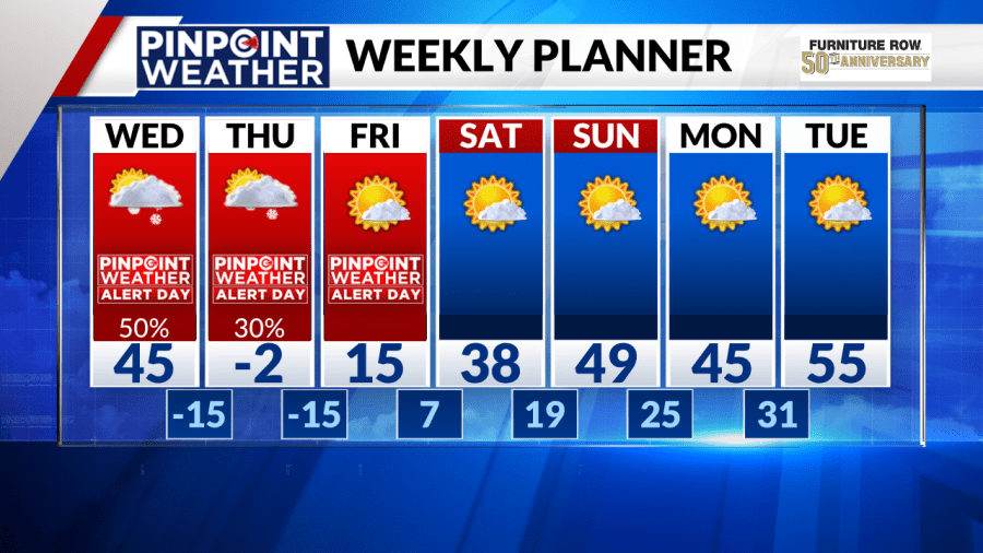
DENVER (KDVR) — Dangerous cold is in store for Denver’s weather and much of the state as an arctic cold front arrives on Wednesday afternoon and brings snow with it too.
A Pinpoint Weather Alert Day has been issued for Wednesday, Thursday and Friday. Snow, wind and extreme cold will have a major impact on the state until the weekend.
Weather tonight: Breezy and cold
Tuesday night will have partly cloudy skies and a bit of a breeze. Lows will drop to the teens.
Weather tomorrow: Fire danger, extreme cold, snow
Wednesday will bring a range of weather impacts.
A red flag warning will be in effect for the foothills from 11 a.m. to 4 p.m. Wind gusts could reach 60 mph. The threat decreases in the late afternoon, when an arctic cold front arrives in the state.
Dangerous wind chill temperatures will be the biggest impact of this system. A wind chill warning has been issued for the Denver metro, Front Range, Eastern Plains and central and northern mountains from 8 p.m. Wednesday to 11 a.m. Friday.
Temperatures on Wednesday heat up to the mid-40s, but they nosedive in the afternoon. and drop below zero starting on Wednesday night. Wind chills of -50 degrees are possible. Exposure to these temperatures will be dangerous for people and pets.

There will also be snow with this system. Snow arrives on Tuesday night in the mountains and is expected in the Denver metro by Wednesday evening. The heaviest snowfall is expected overnight into early Thursday.
The Pinpoint Weather team is forecasting 1-4 inches for the Front Range, Interstate 25 corridor and Eastern Plains. The mountains will see 2-8 inches. Some areas could see localized accumulation in greater amounts.

Looking ahead: Subzero temps, then a warmup
The snow should break apart by mid-morning Thursday and dry out by the evening. But the cold remains. Thursday’s high temperature will stay below zero.

A warmup begins on Friday with a high of 15 degrees. High temperatures above freezing arrive on Saturday and continue to warm through early next week, reaching the mid-50s by Tuesday.

