DENVER (KDVR) — Another round of snow is moving in to the Front Range and mountains on Friday.
This will be a weak cold front that will drop temperatures into the 40s and bring small snowfall accumulations to the lower elevations.
Here are the top three things to know about the storm:
- Timing – Snow showers start midday Friday and end around just after midnight that night.
The scattered snow showers will start north and east of Metro Denver late Friday morning and will slide south and west by midday. There will be spotty showers on the Front Range during the evening commute that could make it slow-going. Dry weather moves back in early Saturday.
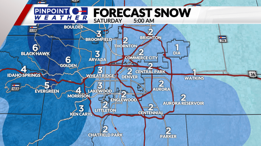
2. Totals – Snowfall totals will be small for most places on the Front Range with higher totals west into the foothills.
Metro Denver will see totals ranging from a dusting up to an inch. The west side of town into the foothills will see about 1 to 3 inches of snow. The biggest totals are expected in parts of Boulder and Larimer counties where up to 6 or 7 inches is possible in isolated spots.

3. Gusty Winds – Winds will be strongest on the eastern plains with gusts up to 50 mph on Friday.
This isn’t a cold storm system, but it will be a windy one for some places. Winds will be strong in the foothills and in Front Range mountains overnight Thursday into early Friday with gusts up to 65mph. Behind the cold front that moves through Friday morning, winds will increase on the plains with gusts up to 50mph.
Metro Denver and the Front Range will see gusts up to 30 mph along with the snow showers on Friday that could create reduced visibility at times.

