DENVER (KDVR) — The next round of rain and snow will return to the state and in the city this weekend.
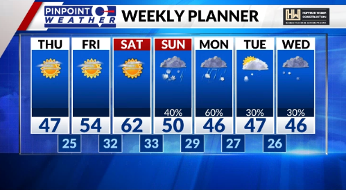
Saturday, a few thundershowers and rain will move into the western half of the state then change to snow as temperatures cool later in the day. The same thing is possible Sunday in Denver, rain then snow late in the day.
This incoming storm isn’t like the last big one. This one will have a lot less energy and less water to work with. Still, though, the pattern will be wet.
Leading into the storm will be sunny and warm days to melt a lot of the recent snowfall that remains. You’ll want to take advantage of the nicer days to eliminate icy spots before the new storm system arrives.
Starting Sunday, and going for most of next week, will be wet weather including both rain and snow chances. The temperature forecast likely will get colder than what is currently projected and that will mean an increased chance for impactful snowfall totals.

If temperatures remain as shown here, snow will be less of a factor due to melting and much of the precipitation staying as rain.
Time will tell.

