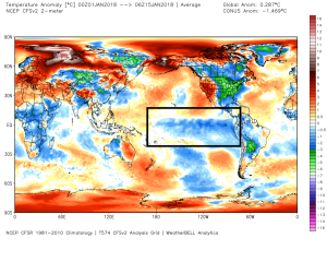
DENVER — La Nina peaks this month before conditions transition to a neutral phase heading into spring.
This could have an important impact on Colorado’s snowpack that could stack the odds in the state’s favor.
Friday’s storm system overdelivered “blower powder” to the central and northern mountains on a northwest flow.
Snowfall amounts beat all forecasts. Ratios were 20:1 with perfect dendritic growth. It was a classic La Nina-flavored setup. There could be a couple more events like this in the next four to five weeks.

La Nina is cooler than normal water in the south Pacific Ocean near the Equator.
Water temperatures in the south Pacific are as cool as they’re going to get. Within the next few weeks, they’ll start to warm, according to the latest computer guidance.

The window for the best snowfall and colder temperatures in Colorado occurs the last week of January and the first three weeks of February.
After that, the window might disappear and abnormally warm air potentially covers most of the West.
Bottom line, look for improving ski conditions in the next four to five weeks.

