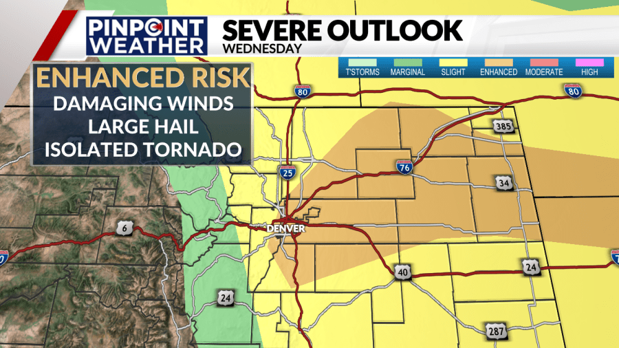
DENVER (KDVR) — The Pinpoint Weather team has issued a Pinpoint Weather Alert Day for Wednesday due to the threat for severe weather across the Denver metro area and Eastern Plains.
Meteorologist Travis Michels said the storms will start to fire up in the early afternoon along the Front Range and will push out to the Eastern Plains through the evening.
Enhanced risk
The threat for the Denver metro area and Eastern Plains has increased from a slight risk for severe storms to an enhanced risk for severe storms.
If you live in the enhanced risk area, you have a higher chance of seeing damaging winds, large hail and even the possibility of an isolated tornado.
The strongest storms will be during the afternoon for the Denver metro area.

Severe thunderstorm watch vs. warning
Severe thunderstorm watches can be issued on days when severe weather is occurring, like gusts above 60 mph and large hail. The National Weather Service said the area for a thunderstorm watch is typically large and covers numerous counties or sometimes, even states.
If you are under a thunderstorm watch, you should be prepared for the possibility of a thunderstorm warning.
Meteorologist Jessica Lebel said a severe thunderstorm warning is issued on a much smaller scale than a watch and usually only includes areas where the storm is at that time. It is also issued for shorter durations, typically under an hour.
In order for storms to be considered severe, they have to include at least one of these three items.
- Hail that is 1 inch in diameter or larger
- Wind gusts 58 mph or greater
- The threat of a tornado (rotation in the storm)
Where to see weather alerts
If a severe weather alert is issued for your area, whether it is a thunderstorm watch or warning, tornado watch or tornado warning, it will always show up at the top of the FOX31 website. You can see all weather alerts here.
The Pinpoint Weather team will continue to update the forecast multiple times each day.

