DENVER (KDVR) — If you have been wondering where all the wet weather has been since April is Denver’s second snowiest month, prepare for a very active week. A spring storm is going to bring heavy rain and snow to Colorado.
A Pinpoint Weather Day was issued on Tuesday and Wednesday as temperatures drop nearly 20 degrees with lots of precipitation covering the state.

Here is everything you need to know to prepare for this April storm:
Timing
The next big storm system pushes into Colorado Tuesday morning.
According to Pinpoint Meteorologist Carly Cassady, the storm will start in the mountains with snow and light scattered rain showers around the Front Range. In the metro, the storm will start out as light rain showers and become more heavy and widespread by the evening. As temperatures drop overnight, snow can be mixed in through Wednesday morning.
The bulk of the storm with the biggest impact will begin Tuesday afternoon and continue through Wednesday afternoon.
On Wednesday, the morning will start off snowy and rainy with big impacts on the roads and on your commute.
After two days of precipitation, the storm will move south and be gone by Wednesday evening.
Temperature change
Get out and enjoy the mild weather on Monday, because temperatures will take a big dive by Tuesday.
Monday will be temperate with highs reaching the low 60s in Denver. On Tuesday, the high will drop nearly 20 degrees in 24 hours with temperatures in the mid to high 40s.
Then just like a roller coaster, Denver will be back into the 60s by Thursday.
Totals
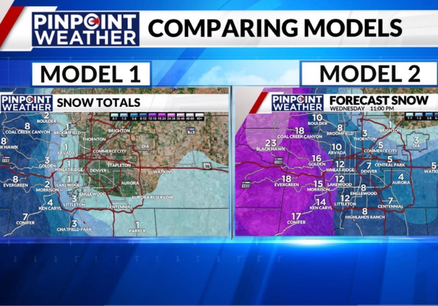
Meteorologist Jessica Lebel said spring storms can be difficult to forecast with very inconsistent computer models when it comes to accumulation. It will all come down to temperatures and elevation.
Take a look at the two computer models:

While model 2 is likely over-forecasting the totals, here is what the Pinpoint Weather team is expecting to see as of Monday morning. However, these totals are likely to change as the storm gets closer:
- Metro Denver – 0-3 inches of accumulation
- Foothills/Palmer Divide – 5-10 inches of accumulation
- Mountains – 4 to 24 inches of accumulation
As the storm continues to change, be sure to keep up to date with the latest forecast with the free Pinpoint Weather app.
Forecast and radar
Whether you have plans to be outside or you just want to stay on top of the forecast, we have you covered.
We have several different radars on our website, which can be used no matter where you are.
- Interactive Radar
- Colorado Radar
- Denver Metro Radar
- Mountain Radar
- Northeast Plains Radar
- National Radar
The Pinpoint Weather team will update Colorado’s Most Accurate Forecast throughout the day on TV with updates on FOX31.

