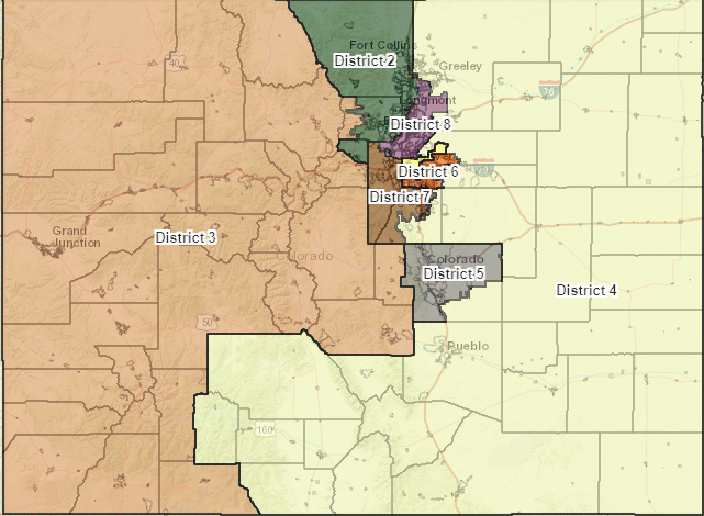
DENVER (KDVR) — The preliminary map for the new Colorado Congressional districts has been released and depending on who you talk to they are insidiously red- or blue-leaning.
Colorado’s population has swollen over the last decade by about 750,000 people. As a result, Colorado now adds one more Congressman to its ranks.
The proposed eighth Congressional district will mash together portions of Jefferson, Broomfield, Adams and Weld counties – including Arvada, Westminster, Thornton, Brighton, Fort Lupton and Platteville.

The Colorado Independent Redistricting Commission, which had to carve the state into new slices that ensure some kind of demographic and geographic sameness, projects the new district will have 21,000 more registered Democrats than Republicans.
The preliminary results satisfy neither party.
According to the commission’s estimated voter affiliation data, the new map will create three heavily Democratic districts, three heavily Republican districts, one district with a slim Republican majority and one district with a slim Democratic majority.
Democrats claim the map creates four Democratic districts and four Republican districts and therefore upsets the state’s new political balance. If anything, Democratic critics say, the commission should have leaned into the recent voting trends and draw the map to deepen Colorado’s 21st century blue lean.
ProgressNow Colorado, a progressive organization, tweeted that the new map is a lopsided giveaway to the GOP.
Republicans, meanwhile, say the maps create a 5-3 Democratic majority, according to the voting behaviors from the 2020 General Election.
Former Republican Speaker of the Colorado House of Representatives, Frank McNulty, said Democrats have more than enough sway in the new Colorado political landscape.
In the previous map, when Colorado only had seven districts, Democrats clearly took four and Republicans the other three.
According to voting registration records, districts 1-5 have stayed firmly in majority status for the last five election years.
Democrats do point out a real trend – the new map will reinforce the recent Democratic trends in District 6 but weaken the long-held Democratic footing of District 7 by moving the line between the two.
District 6 was heavily Democratic in the last two election years, but that wasn’t always the case. In November 2016, District 6 only had 2,900 more registered Democrats than Republicans, and had majority Republican voter bases in both 2014 and 2012.
On the flip side, it will cut into the majority Democrats held in Congressional District 7. That district has enjoyed a comfortable blue majority in each of the last five even years. Under the new map, it has 10,000 more Republicans than Democrats.

