GLENWOOD SPRINGS, Colo. (KDVR) — The Grizzly Creek fire has been burning for a month and has scorched 32,464 acres of land in the Glenwood Canyon area. Because of the location of the fire and the smoke it is producing, Interstate 70 was closed from Aug. 10 to Aug. 24 due to the fire. Below you will find the latest updates. Click here for updates from the US Forest Service.
UPDATE (Oct. 6, 12:00 p.m.): Smokes could be seen from the Grizzly Creek Fire area on Tuesday. Firefighters are monitoring the area to act if needed but no posing threats to the fire line are apparent, and the fire has not grown. It remains at 32,431 acres and 91% contained.
“We’ll continue to see smokes like this until we get some moisture,” said Incident Commander Dan Nielsen. “Please respect the area closure of the fire perimeter and remember the White River National Forest and BLM in this area are in Stage 1 fire restrictions.”
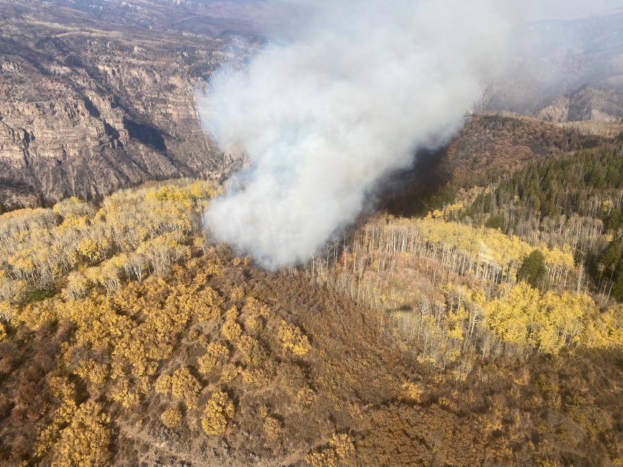
UPDATE (Sept. 15, 3:18p.m.): The fire remains at 32,431 acres and 91% contained. More smokes have been seen in the Grizzly Creek and No Name Creek drainages as the weather warms and conditions dry.
Many of the smokes are interior islands of unburned vegetation that are unlikely to spread outside of the burned perimeter. Suppression line repair along Transfer Trail and other areas will continue today.
UPDATE (Sept. 14, 1:15 p.m.): Two firefighters were taken over the Grizzly Creek drainage this weekend to look at the edge of an uncontained area discovered during a drone search.
The firefighters spend seven hours in the drainage and reached three of the four most prominent hot spots, getting firelines in place around two of them.
“What’s causing the heat and smoke is fire coming from down low in the duff,” Division North Supervisor Dusty Calfee said. “It’s leaf litter, needle cast and small branches, and it’s that creeping, smoldering type of fire that doesn’t always get spotted by helicopters.”
While hot spots like this are not an imminent threat, there is potential that under certain circumstances they could rapidly grow.
More problematic, are the hot spots location within the drainage, which is too steep for firefighters to access by foot.
UPDATE (Sept. 13, 10:55 p.m.): Officials reported no fire activity was seen, so crews worked on repairs today.
UPDATE (Sept. 13, 5:02 p.m.): Firefighters are hoping to get a closer look at a few locations in steep terrain on the Northwest edge of the fire where a small amount of fire activity was spotted yesterday.
A helicopter crew spotted small puffs of smoke in two locations, and a drone flight showed some heat in a third location.
On Sunday, fire managers will do another recon flight to the area, hoping to get closer look at fire activity and decide what, if any, further action is needed.
Repair crews continue work on the Transfer Trail Road today, and the road will remain closed until the work is completed and heavy equipment is removed.
UPDATE (Sept. 12, 11:17 p.m.): Coffee Pot Road was re-opened to the public, allowing hunters and recreationists back into the BLM and National Forest lands in the area.
Roads going south off of Coffee Pot Road remain closed, due to firefighting activity, and the Transfer Trail Road also remains closed.
UPDATE (Sept. 12, 11:41 a.m.): Coffee Pot Road is reopening today.
Officials encouraged people to drive and hunt carefully, as there are still firefighting crews working in the area.
“Be mindful in doing your part to minimize road damage as you drive onto open side roads north of Coffee Pot Road,” said Bureau of Land Management Colorado River Valley Field Manager Larry Sandoval. “If your vehicle begins to cause ruts, please consider other access options, and know that repaired fire suppression lines are not open to motorized travel.”
UPDATE (Sept. 10, 10:54 p.m.): The number of personnel assigned to the fire decreased further today from 270 to 116. The fire received little precipitation today and drier conditions are expected tomorrow.
UPDATE (Sept. 9, 8:48 p.m.): With the Alaska team departing, the total number of people assigned to the fire decreased from 383 to 270.
“Fire resources will continue to be released to travel home or to new fires,” firefighting officials said.
The fire has not grown in 11 days.
UPDATE (Sept. 9, 2:15 p.m.): Because of weather, fire personnel are mostly being held away from the fire lines until conditions dry. The weather also helped tamper the fire and moderate behavior.
Because fire activity has been limited for more than a week, incident managers are expecting to provide fewer updates moving forward.
UPDATE (Sept. 8, 10:53 p.m.): A Type 3 team will take command of the fire tomorrow. They shadowed the Alaska Incident Management Team today.
“The teams are working closely with management agencies to ensure a smooth transition as priorities shift from suppression to suppression repair,” firefighting officials said.
UPDATE (Sept. 8, 8:15 a.m.): The fire is now 91% contained with no growth overnight.
UPDATE (Sept. 7, 10:43 p.m.): The fire remained at the same acreage but the containment percentage rose from 83 to 91. The number of personnel was reduced slightly from 402 to 383.
UPDATE (Sept. 7, 8:27 a.m.): There were expected flare ups and smoke in the interior of the Grizzly Creek Fire over the weekend, but incident managers say it largely behaved as expected.
The two areas where the fire is not considered contained are the Grizzly Creek drainage on the northwest corner of the fire and the Cinnamon and Devil’s Hole creek drainages to the south. Managers said even with the wind events in the past week the fire has stalled in both directions.
Crews are prepared for more hot temperatures Monday, before a cold front drops temperatures significantly and brings rain and snow with it.
“We have one more big day in front of us,” incident commander Norm McDonald with the Alaska Type 1 Incident Management Team said, alluding to the radical forecast. “We need to focus on holding what we have and quickly shift to safety to weather this out.”
UPDATE (Sept. 6, 3:09 p.m.): High temps, low humidity and 20-25 mph winds will most likely increase fire activity. Conditions prompted a Red Flag Warning issued for Monday from noon to 9 p.m.
Despite weather conditions, there has been no activity outside the fire perimeter keeping the total acreage at 32,464 with 83% containment for the seventh day in a row.
With the forecast of snow/rain on Tuesday, Deputy Incident Commander Tom Kurth said the strategy is “to hold fast as critical conditions prevail while anticipating the rapidly deteriorating conditions predicted on Tuesday.”

UPDATE (Sept. 5, 11:03 p.m.): Officials report that the containment percentage – not the acreage – of the fire continues to increase. Flames and smoke have significantly reduced, but the amount of work to be done along the fire perimeter has changed, not lessened.
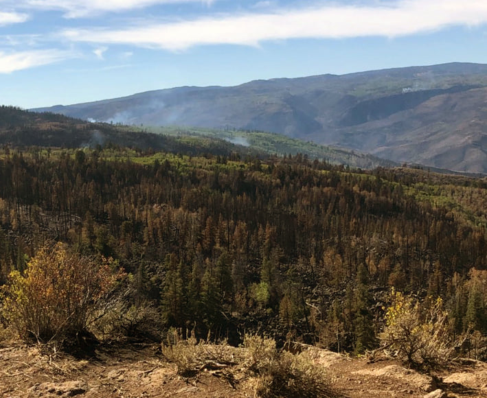
UPDATE (Sept. 5, 7:30 p.m.): There was visible smoke north of I-70 in the No Name and Grizzly Creek drainages, as well as the Ike Creek drainage to the south of I-70 on the southeast side of the fire.
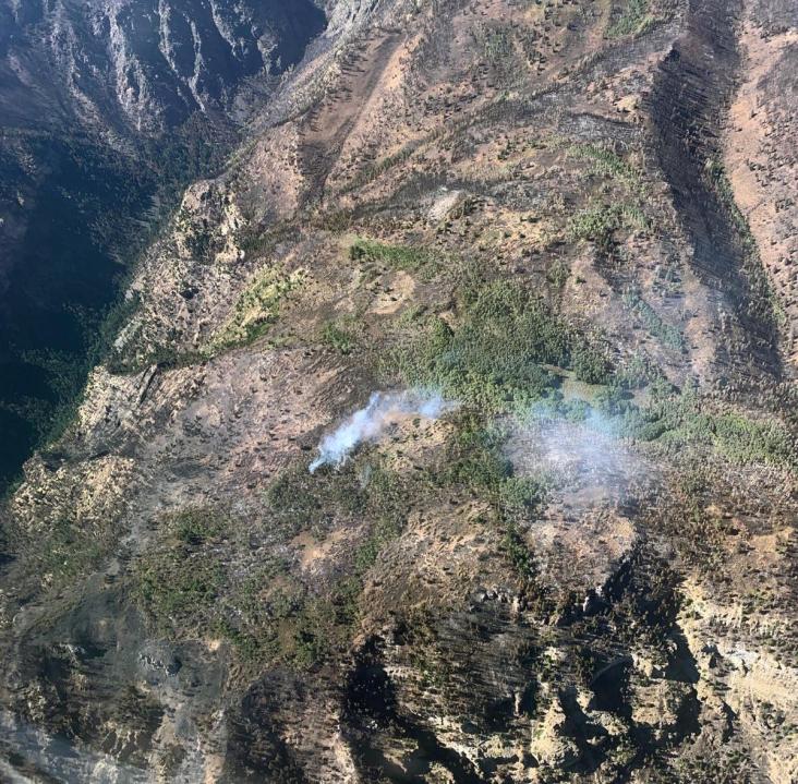
Officials say: “These smokes are the result of pockets of green fuels burning up. They are well within the fire perimeter and do not pose a threat to containment lines. We are using water drops from helicopters to cool them off. Please do not call 911. This type of fire activity is expected with the hotter, drier conditions the past few days and will continue until we get significant rain or snow.”
UPDATE (Sept. 5, 11:54 a.m.): The Alaska Type 1 Incident Management Team, which took control of the fire on Aug. 25, is set to depart on Tuesday. The team met with other firefighting officials about the plan to transition control to a smaller, Type 3 team.
“We’ve got a really good plan in place for what kind of organization we’re going to leave behind so we can set the incoming team up for success,” Incident Commander Norm McDonald said in a statement. “That’s our goal.”
UPDATE (Sept. 4, 9:15 a.m.): “We’re on track to have suppression operations completed by Sunday,” reported Karen Scholl, operations planning chief for the Alaska Incident Management Team, which has command of the fire.
That’s good news for people who live, work and play in the areas affected by the fire. According to Scholl, of the 78.5-mile perimeter about 65 miles has been secured.
With fire activity minimal, the focus has been on repairing dozer lines constructed to control the attack. So far 31 miles of lines have been repaired and another 7.5 miles are pending. That leaves 27.5 miles of dozer lines that are still being assessed.
UPDATE (Sept. 3, 5 p.m.): The closure area near the fire has been reduced, according to the Bureau of Land Management (BLM) and White River National Forest.
Sweetwater Road is open. It offers an alternate access point into the eastern part of Flat Tops Wilderness. Clinetop Mesa Road is open. The Heart Lake and Deep Lake area is open and accessible from the west.
Additionally, the BLM trails at Onion Ridge and Keyser Creek are open.
Coffee Pot Road and Transfer Trail Road remain closed. The western boundary of the closure includes Forest Service roads 602 and 637.
The Boy Scout/Lookout Mountain, Grizzly Creek, Hanging Lake, Mitchell Creek and No Name trails are closed, officials said.
Additionally, the recreation areas and boat ramps on the Colorado River from Dotsero through Glenwood Canyon to No Name are closed.
Cottonwood Landing is open to put in and take out. Lyons Campground is open to take out only.
UPDATE (Sept. 3, 8:40 a.m.): Wednesday was the fourth day in a row with no growth of the Grizzly Creek Fire.
Warm and dry conditions led to some unburned patches catching fire in the interior, but according to incident management they were at least 1/4 mile from the perimeter and posed no threat to containment.
“It’s a good indicator of what we’ll be seeing over the next four or five days,” Alaska IMT Operations Chief Jon Glover said, alluding to a warming, drying trend that is expected to spawn interior flare-ups of unburned fuel the next few days.
UPDATE (Sept. 2, 11:02 p.m.): Containment of the fire has grown from 75% to 82%. The number of personnel fighting the fire rose slightly to 603.
UPDATE (Sept. 2, 1:30 p.m.): All pre-evacuation notices in Eagle County have been lifted, the sheriff announced.
UPDATE (Sept. 2, 9:15 a.m.): Nearly 1/4 of an inch of rain fell Monday and Tuesday and the fire, allowing firefighters to take advantage of the soak. This is going to help contain the fire’s spread and make sure areas where it is contained are less likely to rekindle.
“A slow, steady rain does a really good job of penetrating the fuels,” said fire behavior analyst Chris Moore with the Alaska Incident Management Team that has command of the fire. “If you get one big dump of rain it runs off before it can be absorbed. This type of rain does a lot better for moistening those fuels.”
Fire managers also had a reminder for hunters that many roads and trails in the area of the fire remain closed. Sections of the White River National Forest and the nearby Bureau of Land Management lands are also still in the fire area.
Firefighters said there have been several instances in which they’ve had run ins with mountain bikers.
“There are hundreds of miles of trails that remain open to mountain biking outside the closure area,” noted Alaska IMT Incident Commander Norm McDonald. “Out of respect for firefighter and public safety, we ask mountain bikers to adhere to the closures. The last thing we want is a surprise encounter between a mountain biker and a piece of heavy equipment.”
For maps and closure info, go to White River NF closure area or BLM closure order and closure map.
UPDATE (Sept. 1, 10:52 p.m.): A ridge of high pressure will bring more challenging firefighting conditions to the area on Wednesday. Drier, warmer weather is expected alongside low humidity, officials said.
UPDATE (Sept. 1, 8:45 a.m.): For the second day in a row the fire lines held despite wind gusts of more than 40 mph. There was no increase in acreage and the containment bumped up to 75%.
The stronger winds occurred above 8,000 feet in elevation, and winds in the valleys weren’t as strong.
“A lot of the fire was protected, which is a good thing,” Incident Meteorologist Nathan Heinert said.
Overnight rain helped dampen the fire, and the incident management team said it was thankful there wasn’t enough rain to cause runoff and flooding risks.
Suppression repairs are underway along Coffee Pot Road, Bair Ranch, Red Canyon and No Name in the areas where burn operations or other fire line creation damaged the environment.
The US Forest Service has announced that the fire was manmade, although the specifics are still under investigation.
UPDATE (Aug. 31, 11:45 p.m.): No growth of the fire was reported but the containment increased to 75%. The number of personnel working on the fire was reduced from 626 to 589.
UPDATE (Aug. 31, 9:11 p.m.): Authorities provided an update and hosted a Q & A earlier today.
UPDATE (Aug. 31, 11:12 a.m.): Some crews were pulled from the fire line yesterday afternoon due to a wind storm that had gusts up to 40 miles per hour. Managers said no injuries were reported and firefighters were able to return to the line about an hour later.
The wind storm did not impact the overall containment, but managers said lines will be challenged today as another wind storm moves in.
“If we get any spotting or flare ups, we’ll have personnel in the appropriate places to take action,” said operations planning section chief Karen Scholl with the Alaska Incident Management Team. “We have safety zones for firefighters identified if we need them.”
UPDATE (Aug. 30, 10:04 p.m.): No evening update on growth or containment but firefighters were shown some love from the community when they received these today.
UPDATE (Aug. 30, 4:51 p.m.): The fire got rain on Saturday but that also made for slippery, unsafe conditions for firefighters. Efforts were put on hold until the storms passed. Isolated storms are expected through Monday but then fuels are expected to dry out which could be a critical fire day with low relative humidities and winds gusting to 37 mph.
Crews are now working some of the roughest and most inaccessible portions of the fire. Helicopters were required to deliver two additional crews to an uncontained section of the fire perimeter, where they are working on a fireline to connect the Grizzly Creek rim to the No Name Creek rim.
Interstate 70 remains open to two-way traffic. Motorists should expect delays for utility work and firefighting operations, or in the event of debris flow due to rain.
Road closures remain in effectfor Coffee Pot Road, Transfer Trail Road and areas of the Flat Top Wilderness accessed by those roads, as do many surrounding White River National Forest and BLM roads.
UPDATE (Aug. 29, 7:41 p.m.): The fire is now 73% contained and burning 32,464 acres. One of the team information officers provided an update on Coffee Pot Road and other areas of the fire.
UPDATE (Aug. 29, 9:10 a.m.): Drivers planning to travel through Glenwood Canyon on I-70 should be prepared for potential closures. CDOT says safety closures are possible due to mudslides in the burn area.
UPDATE (Aug. 28, 10:51 p.m.): Containment has increased slightly to 71%. The size of the fire also grew 40 acres to 32,448 acres.
UPDATE (Aug. 28, 3:41 p.m.): The Bureau of Land Management has reopened two boat ramps in Dotsero that were closed due to the fire.
Cottonwood Island boat ramp and Lyon’s Gulch boat ramp are both now accessable.
The Dotsero Landing remains closed.
UPDATE (Aug. 28, 9:34 a.m.): Helicopters used water drops to support firefighters working on uncontained portions of the perimeter on Thursday. Firefighters are focusing their efforts on the No Name and Grizzly Creek drainages on the northwest edge of the fire, as well as the southern perimeter near Green Lake, which remain the two biggest challenges for fire managers.
I-70 remains open to two-way traffic but periodic delays for power line and utility repair and firefighting operations should be expected.
Road closures remain in effect for Coffee Pot Road, Transfer Trail Road and areas of the Flattops accessed by those roads, as do many surrounding White River National Forest and BLM roads.
Karen Scholl provided the operational briefing on Friday morning.
UPDATE (Aug. 27, 11:59 p.m.): While the fire grew about 100 acres today to 32,408, containment also rose by 6% to 68%. Overall staffing shrunk slightly to 663.
UPDATE (Aug. 27, 4:40 a.m.): Three 20-person fire crews from Alaska will arrive in Colorado Friday to help fight the Grizzly Creek and Cameron Peak fires.
An Incident Management team from Alaska has been responsible for the Grizzly Creek fire since yesterday morning, although it’s unclear if that is directly connected to the arrival of Alaskan firefighters.
UPDATE (Aug. 27, 11:36 a.m.): Fire managers say Wednesday was a “tense” day due to a flash flood watch over the Grizzly Creek Fire area.
Heavy rains never developed, however managers say the situation highlighted flooding concerns in the area where trees and brush were destroyed by the fire.
Fire behavior was tame over most of the fire Wednesday. Helicopters were used to control hot spots in the No Name and Grizzly Creek drainages. Elsewhere firefighters mopped up after a multi-day operation on Spruce Ridge above Bair Creek.
UPDATE (Aug. 27, 4:28 a.m.): Rain fell on the Grizzly Creek Fire on Wednesday.
UPDATE (Aug. 26, 11:48 p.m.): The fire grew slowly today to 32,302 acres — up from 32,060 this morning. Drier conditions are expected Thursday. However, the weather pattern will change Friday, with thunderstorms more likely.
“The probability of getting enough rain for debris flows in Glenwood Canyon is approximately 8%,” officials said.
UPDATE (Aug. 26, 2:22 p.m.): A flash flood watch has been issued for part of central Colorado, including the area where the Grizzly Creek Fire has been burning.
UPDATE (Aug. 26, 9:45 a.m.): Management of this fire was handed over from Great Basin Team 1 to Alaska Type 1 at 6 a.m. today.
A release said that Tuesday was another successful day of containment, and the containment lines have continued to hold.
Firefighters Tuesday wrapped up a burn operation on Spruce Ridge above Bair Ranch.
I-70 remains open for two-way traffic but temporary delays and closures are expected due to power line and road repairs.
UPDATE (Aug. 25, 11:11 p.m.): Containment jumped from 44% to 61% today. The latest acreage estimate remains at 32,060. The number of people fighting the fire rose slightly to 806.
UPDATE (Aug. 25, 10 a.m.): The fire grew to 32,060 acres with 44% containment on Tuesday morning.
UPDATE (Aug. 25, 4:05 a.m.): CDOT said I-70 is back open between Exit 116: CO 82; Glenwood Springs (Glenwood Canyon) and Exit 133: Dotsero (Dotsero).
UPDATE (Aug. 24, 7:25 p.m.): CDOT just announced that I-70 will be temporarily closed both ways between Exit 116: CO 82; Glenwood Springs (Glenwood Canyon) and Exit 133: Dotsero (Dotsero) for emergency operations.
There has been a flare-up of Grizzly Creek fire activity west of Bear Ranch.
UPDATE (Aug. 24, 3:45 p.m.): In addition to the reopening of I-70, Eagle County announced that Cottonwood Pass has reopened without restrictions.
On Sunday, the pass was reopened to local traffic and critical need vehicles. Between the time that happened and when the pass fully reopened at 2 p.m. a total of 250 requests were authorized for use of the pass.
“As always,” Eagle County said, “large vehicles should not travel through Cottonwood Pass.”
UPDATE (Aug. 24, 9:21 a.m.): The fire grew to 30,719 acres on Monday morning with 33% containment.
Fire managers said the hot and dry weather conditions yesterday allowed the fire to grow, this include flames in areas that the fire had previously passed by.
Increased fire activity is expected again today as crews continue controlled burns in the area around Bair Ranch.
UPDATE (Aug. 24, 6:21 a.m.): I-70 has reopened between Glenwood Springs and Gypsum.
UPDATE (Aug. 23, 8:21 p.m.): Pre-evacuations have been lifted.
UPDATE (Aug. 23, 4:39 p.m.): Due to continued progress being made on the Grizzly Creek Fire, the Eagle County Sheriff’s office has lifted pre-evacuation orders for the following locations: Sweetwater Road, Dotsero and Lower Colorado River Road.
UPDATE (Aug. 23, 4:31 p.m.): Operational Update with Operations Section Chief Jeff Surber
UPDATE (Aug. 23, 2:48 p.m.): The Grizzly Creek Fire grew 370 acres on Saturday. It is now 30,362 acres at 30% containment. Officials are expecting moderate to active fire behavior on both the West and East side of the fire on Sunday as the weather remains hot and dry with light winds.
It will be hazy and smoky on Sunday. Glenwood Springs and Eagle will gradually see clearing from USG to moderate through the day. Communities of Vail, Basalt, Carbondale and Aspen will be in the moderate range throughout the day and could see conditions of unhealthy for sensitive groups (USG) for short periods of time. All areas will see lingering smoke in the morning and evening hours on Sunday through to Monday.
Check out the latest map.
UPDATE (Aug. 22, 10:07 p.m.): The fire is burning 30,362 acres and is at 30% containment.
UPDATE (Aug. 22, 8:47 p.m.): Eagle County Office of Emergency Management and the Eagle County Sheriff- Cottonwood pass to open. See details at this link:http://www.ecemergency.org/2020/08/cottonwood-pass-to-open-to-local.html
UPDATE (Aug. 22, 3:50 p.m): On the east side of the fire, more burnout operations are planned to remove fuel between the main fire and containment lines and to secure the line from I-70 to the top of Spruce Ridge. On the west side of the fire, crews plan to work in steeper sections of Bear Creek and in the Lookout Mountain Park area.
UPDATE (Aug. 22, 11:36 a.m.): Fire managers say that crews contained the fire to the northwest at the I-70 corridor and No Name drainage. The area of Coffee Pot Road to I-70 is reported to also be contained.
UPDATE (Aug. 21, 8;31 p.m.): Heavy smoke could be seen from a burn out operation near Ike Creek as part of battling the Grizzly Creek Fire.
UPDATE (Aug. 21, 5:02 p.m.): Fire managers say the Grizzly Creek fire is partially contained along the northern side, and they don’t see many areas for concern. This was done by using roads in combination controlled burns and timbercuts made with heavy equipment.
On the south side of I-70, burn operations to create a line the fire cannot pass are in progress in several areas, including the eastern edge of the fire.
At the southwest corner air support is still dropping fire retardant to help abate the flames so heavy equipment can be used to create a timbercut line.
UPDATE (Aug, 21, 8:35 a.m.): The fire grew minimally on Friday to 29,992 acres. Containment remains at 11%.
UPDATE (Aug, 20, 10:35 p.m.): Containment of the fire has increased from 4% to 11%. The number of people fighting the fire increased from 820 to 889.
UPDATE (Aug, 20, 4:10 p.m.): Fire managers at the Grizzly Creek Fire shared a video showing some of the damage that has been caused in the area near Bair Ranch. While the fire has already been stopped on one side of the ranch, a planned burn is underway to protect the full area around the ranch.
UPDATE (Aug. 20, 10:14 a.m.): According to fire managers, most of the wildfire’s spread on Wednesday occurred on the south and west sides of the fire area. In the Rawah Wilderness, the fire burned into timberline, a natural barrier that is expected to limit further growth in that direction.
Temperatures for today are expected to be in the 70s where the fire is located with northwesterly winds of 10 to 20 mph.
UPDATE (Aug. 20, 9:02 a.m.): The Grizzly Creek Fire is now listed at 29,732 acres, a growth of about 1,500 acres since the most recent update.
UPDATE (Aug. 20, 4:25 a.m.): There will be isolated storms again today but it will not be enough to put a dent in the fire, according to the FOX31 Pinpoint Meteorologists.
UPDATE (Aug. 19, 11:17 p.m.): Officials provided a map of the National Forest closure area:
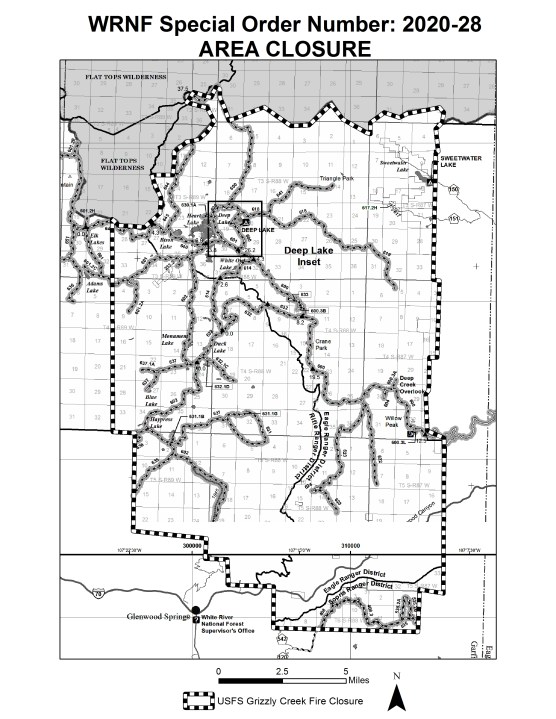
UPDATE (Aug. 19, 2:13 p.m.): The US Forest Service has issued a closure for part of the White River National Forest.
The closure area is the Forest boundary south of Glenwood Canyon north to the Flat Tops Wilderness boundary. The western boundary of the closure extends to about Adams Lake, and the eastern boundary is the eastern Forest boundary in the Sweetwater/Coffee Pot Road area. Forest road closures include Coffee Pot Road (FSR 600) and Transfer Trail (FSR 602).
Clintetop Mesa Road (FSR 603) remains open.
UPDATE (Aug. 19, 10:12 a.m.): The Grizzly Creek fire is currently 28,030 acres according to overnight infrared scans, with active perimeters in various canyons. Dry conditions and hot weather will continue to be a challenge for the next few days. The fire is expected to continue to grow along all fronts where it can find available fuels to burn, according to the US Fire Service.
UPDATE (Aug. 19, 4:17 a.m.): In an update on the Grizzly Creek Fire Facebook page, from August 10th thru 16th, airtankers dropped more than 487,703 gallons, or 50.6 miles worth of retardant on #GrizzlyCreekFire. Those numbers don’t even include drops by agency and partner helicopters, Department of Interior single engine airtankers, modular airborne fire fighting systems, or airtankers contracted with the state of Colorado that have been working to implement the full suppression strategy.
UPDATE (Aug. 18, 11:25 p.m.): While the size of the fire increased slightly to 27,269 acres, containment also crew from 0% to 4%. Additionally, the number of people fighting the fire rose by nearly 100 to 820.
UPDATE (Aug. 18, 6:21 p.m.): Crews spent part of the day clearing debris from I-70 after a massive rock tumbled down near the Hanging Lake Exit.
“There was a piece of rock the size of a Volkswagen Bug that came down here. It hit the westbound lanes, bounced and hit the guard rail, shattered and took out part of the guard rail before it hit the river,” a CDOT official said.
Firefighters are focus on the south side of Bair Ranch, the upper area of Coffee Pot Road and the No Name drainage.
UPDATE (Aug. 18, 11:15 a.m.): An update released from the Great Basin Incident Management Team late Tuesday morning showed that the Grizzly Creek Fire grew to 27,000 acres.
UPDATE (Aug. 18, 11:00 a.m.): An update was posted on the Grizzly Creek Fire Facebook page Tuesday morning sharing an updated map of the fire. The fire has burned 25,007 acres with 0% containment.
UPDATE (Aug. 17, 10:57 p.m.): An update was posted on the Grizzly Creek Fire Facebook page on Monday evening. No Name Creek Drainage Burnout Operation Discussion by Planning Operations Section Chief, Tyler Monroe.
UPDATE (Aug. 17, 7:21 p.m.): There is no estimated time frame for current road closures due to the Grizzly Creek Fire.
UPDATE (Aug. 17, 12:42 p.m.): The US Forest service says this fire has the potential for “extreme: spread if the winds and slope align today.
“Fire spread is primarily wind and topography driven. Extreme fire behavior is expected when winds and slope align. Fire is burning in and near several large canyons,” the fire service said.
UPDATE (Aug. 17, 9:00 a.m.): The fire has grown to 25,007 acres with 0% containment.
UPDATE (Aug. 16, 6:00 p.m.): Watch the Sunday update for the Grizzly Creek Fire.
UPDATE (Aug. 16, 3:09 p.m.): As of Sunday morning, the Grizzly Creek Fire was burning 25,690 acres with 625 personnel working on containing the blaze.
By mid-afternoon the fire made a run from Grizzly Creek to Coffee Pot Road. Fire on the southeast edge is holding just shy of Spruce Ridge. It pushed between the Deadman Canyon and Devil’s Hole Canyon. The fire has moved to the canyon rim and is holding.
UPDATE (Aug. 15, 7:17 p.m.): An American Airlines flight was diverted from landing at Eagle County Airport to Denver International Airport due to poor visibility from the Grizzly Creek Fire.
UPDATE (Aug. 15, 10:50 a.m.): New video from the Eagle County Sheriff’s Office provides a better perspective of the Hanging Lake area. Most vegetation and the boardwalk appear to have survived the fire.
UPDATE (Aug. 15, 9:07 a.m.): The Bureau of Land Management says several recreation sites and boat ramps near the fire in Eagle County are closed.
The closure is along the southern portion of Colorado River Road (RD 301) near Dotsero. The Cottonwood Landing Boat Ramp, Lyons Campground and Boat Ramp, and Dotsero Boat Ramp are included in the closure area.
UPDATE (Aug. 15, 8:54 a.m.): The fire has grown to 19,440 acres, according to officials. Containment remains at 0%.
UPDATE (Aug. 14, 10:49 p.m.): The official acreage estimate remains at 13,441, according to officials’ latest update. However, that could change when new mapping becomes available Saturday.
UPDATE (Aug. 14, 9 p.m.): Firefighters released an aerial photo of Hanging Lake, which appears to have been spared from the fire so far:
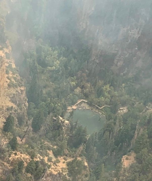
UPDATE (Aug. 14, 6:16 p.m.): Officials say as of Friday evening, Hanging Lake has not been seriously impacted by the fire.
“We’re happy to report that the main front and the most intense part of the fire did not seem to impact Hanging Lake or the immediate area,” said Scott Fitzwilliams, supervisor of the White River National Forest.
UPDATE (Aug. 14, 5:36 p.m.): Independence Pass has reopened to passenger vehicles, according to the Colorado Department of Transportation.
“Eastbound and westbound traffic on either side of the pass will encounter alternating traffic flow controlled by flagging personnel. Motorists are advised that only passenger vehicles, such as cars, SUVs and vans are allowed,” CDOT said in a statement.
CDOT closed the pass earlier this week due to safety concerns after numerous semi-trucks got struck while trying to navigate the road.
The agency said drivers should expect a heavy law enforcement presence.
UPDATE (Aug. 14, 2:03 p.m.): The American Red Cross of Colorado has opened an evacuation center in Edwards. Battle Mountain High school is located at 151 Miller Ranch Rd.
Red Cross volunteers are there and are prepared and ready to accommodate anyone needing information or other assistance. They will also have access to emergency supplies and support.
UPDATE (Aug. 14, Noon): Gov. Polis toured the Grizzly Creek Fire Friday before heading off the the Pine Gulch Fire near Grand Junction. Police thanked the 1,000+ men and women working to fight these wildfires.
“The Grizzly Creek Fire is now the number one fire priority in the entire nation and we are successfully receiving and deploying resources from across the country. The top priorities for the Grizzly Creek Fire include protecting and re-opening I-70 and protecting residents and homes in the area,” he said.
UPDATE (Aug. 14, 11:30 a.m.): FOX31’s Vicente Arenas has learned that Hanging Lake is three miles inside the fire line.
At this time it’s unclear how much damage has been caused to the vegetation around the lake.
Yesterday, all reservations for Hanging Lake through Aug. 19 were canceled. People were being asked to reschedule.
UPDATE (Aug. 14, 10:30 p.m.): An adjusted measurement from the Forest Service lists the fire at 13,441 acres. FOX31 is working to learn more about how these measurements are made and what would lead to a decreased size.
I-70, Cottonwood Pass, Independence Pass, Hagerman Pass Road and Crooked Creek Bass between Sylvan Lake and Thomasville remains closed.
UPDATE (Aug. 14, 6:20 a.m.): The fire doubled in size overnight, burning a total of 14,663 acres.
UPDATE (Aug. 13, 8:54 p.m.): The Garfield County Sheriff’s Office has ordered evacuations for Bair Ranch, Sweetwater and Coffee Pot Springs. The town of Dotsero is under a pre-evacuation notice.
An evacuation center has been established at the Gypsum Recreation Center.
UPDATE (Aug. 13, 7:02 p.m.): New video from the Colorado Department of Transportation shows how the fire has devastated Glenwood Canyon.
UPDATE (Aug. 13, 2:07 p.m.): Independence Pass is going to remain closed concurrently with the I-70 closure, according to Colorado State Patrol.
UPDATE (Aug. 13, 12:30 p.m.): The Glenwood Caverns Adventure Park is closed so crews can work on fire mitigation.
A Type 1, 20-person hotshot crew out of Durango is on the mountain to assess the risk and protect the park.
FOX31’s Vicente Arenas was live at the park Wednesday night and at that time the fire was visible over a ridge.
Since then, the fire has grown by about 50% and is within five miles of the park.
“It is hard to express just how grateful we are for these hotshots at the park and for all of the first responders battling the Grizzly Creek Fire and other fires throughout the country. What they do is truly incredible, and we are all praying for their safety and for rain,” Steve Beckley, who owns Glenwood Caverns Adventure Park with his wife Jeanne, said. “We aren’t sure when we will reopen but ask guests and others with questions to follow our Facebook page for updates. Our phones are really busy, so the best way to contact us is via email.”
UPDATE (Aug. 13, 11:00 a.m.): According to the United States Forest Service, there are six 20-person hand crews working to contain the fire alongside six helicopters, 11 engines and one water tender. The forest service said it is also waiting on equipment to help clear trees and remove brush to help create a break.
“On Wednesday afternoon, the fire reached the bottom of the No Name drainage, which will be a focus of firefighters today. Hotshot crews are working to contain spot fires along the ridge south of No Name drainage, and establish an anchor point and firelines,” a release from the forest service said.
The forest service warned that residents in north Glenwood Springs should be prepared for pre-evacuation notices as conditions change.
The unofficial suspected cause of this fire is a spark from a blown tire or chain dragging.
A Red Flag warning is in place for across northwestern Colorado, to go along with this Rocky Mountain National Park has issued a fire ban.
UPDATE (Aug. 13, 9:15 a.m.): The Grizzly Creek Fire has now surpassed 6,000 acres and is expected to keep growing throughout the day. A more details update is expected around 11 a.m.
UPDATE (Aug. 13, 8 a.m.): I-70 remains closed as the Grizzly Creek fire continues to grow. Additionally, CDOT has closed Independence Pass because many vehicles using it as a cut through to avoid the posted detour were unable to successfully navigate it.
The fire has grown to about 4,600 acres and remains 0% contained.
Because of hot, dry and gusty conditions a Red Flag Warning has been issued for northwestern Colorado, including the area near Glenwood Springs where the fire is burning.
UPDATE (Aug. 12, 10:52 p.m.): The fire has grown to 4,624 acres. According to officials, 238 people are assigned to fighting the fire.
UPDATE (Aug. 12, 8:15 p.m.): Officials held a Facebook Live to provide updates on firefighting efforts. It can be viewed below:
UPDATE (Aug. 12, 6:42 p.m.): Firefighting officials dispelled rumors about evacuation orders in Glenwood Springs. Currently, no evacuation or pre-evacuation orders are in place.
UPDATE (Aug. 12, 4:40 p.m.): The Colorado Department of Transportation has closed Highway 82 over Independence Pass. The closure is between just east of Aspen and just west of Twin Lakes. CDOT said the closure is due to heavy traffic and safety concerns. CDOT said several semi-trucks got stuck while trying to navigate the pass.
UPDATE (Aug. 12, 3:35 p.m.): FOX31 reporter Vicente Arenas has been watching this fire in person for the past 90 minutes from the Glenwood Caverns Adventure Park. He reports that it recently flared up with large flames and is now producing some darker black smoke.
UPDATE (Aug. 12, 2 p.m.): Use caution when detouring around the I-70 closure caused by this fire. The official detour given by CDOT will keep you on accessible roads. Other unapproved detours provided by GPS/navigation apps can send drivers onto unpaved roads and into dangerous situations.
UPDATE (Aug. 12, 12:05 p.m.): While firefighters work toward containing the Grizzly Creek Fire, the Eagle County Sheriff’s Office is investigating what may have started it.
According to the department, the preliminary evidence points to sparking on the road possible caused by a sparking rim from a blown tire or dragging chain.
ORIGINAL POST: Interstate 70 is closed in both directions between Glenwood Springs and Gypsum due to the Grizzly Creek Fire.
The closure extends from mile point 116 to 140.
As of Wednesday morning, the fire had burned 3,700 acres and was 0% contained. Officials said 211 people are involving in fighting the fire from the ground and air.
The I-70 safety closure will allow the Colorado Department of Transportation to assess two bridges located near where the Grizzly Creek Fire started, as well as an increased rockfall hazard in Glenwood Canyon. Both assessments are taking place Tuesday, according to CDOT.
Rockfall has been reported and is likely due to burned vegetation no longer holding rocks in place.
CDOT has paused some construction projects to allow for detour traffic. CDOT asks that motorists not use Cottonwood Pass (Eagle & Garfield counties) or Independence Pass as detour routes, as these roads are not built for heavy traffic or commercial, oversize vehicles. Vehicles over 35 feet in length may not use Independence Pass at any time. This includes a vehicle and trailer that, together, exceed 35 feet.
DETOUR ROUTES
Below is a map of recommended detour routes between metro Denver and Grand Junction:
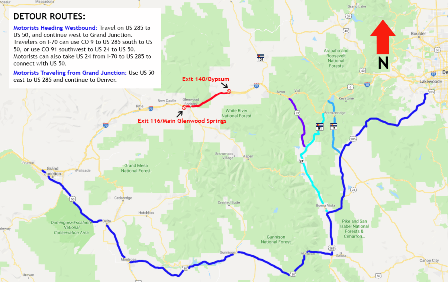
Drivers should anticipate additional traffic on these routes. While some construction projects have been put on hold, travelers should be aware of possible construction impacts on US and state highways. CDOT recommends that through traffic on I-70 use a southern detour route, due to construction on commonly used northern alternate routes.
WESTBOUND: Denver metro area motorists can travel on US 285 to US 50, and continue west to Grand Junction. Travelers on I-70 can use CO 9 to US 285 south to US 50, or use CO 91 southwest to US 24 to US 50.
EASTBOUND: Motorists traveling from Grand Junction can use US 50 east to US 285 and continue to Denver. Motorists headed to areas west of Denver can also use the westbound detour in reverse.
For residents and businesses north of I-70, the following alternate routes are best:
WESTBOUND: Motorists can connect to US 40 via CO 9 or CO 131. To continue to Grand Junction, take CO 139 south to I-70. CDOT advises commercial traffic to use CO 9 instead of CO 131, for safety purposes. Please note that while CO 13 is open at this time, it is not a recommended detour due to construction. Oversize commercial vehicles are not allowed on CO 13 due to construction.
EASTBOUND: Near Fruita, motorists can travel north on CO 139 to US 40, then south on CO 131 or CO 9, returning to I-70. As stated above, CO 13 is not recommended due to construction.
CDOT says there is no estimated time when the interstate will reopen.
Glenwood Springs officials have asked people to not water their lawns for the next 48 hours.
“The City of GWS has began pumping water from the Roaring Fork River station to protect the water supply from fire retardant,” the City said.
The cause of the fire is under investigation.
Previous updates:
Click here for live traffic maps.
