DENVER — Whether it’s by foot, by car or with a frosty beverage of some kind, whether you’re deep in the woods or just a hop, skip and a jump from Denver, there are all manner of great ways to see the autumn colors in Colorado this year.
It’s one of our favorite times of year, and we want to help you enjoy it!
As we do every year, we here at FOX31 have put together a list of a few great ways you can get out and check out the state’s changing colors and fall foliage.
By foot
[protected-iframe id=”5123d0e31a2730ec6897763e48e19d8c-29290497-36744130″ info=”https://www.google.com/fusiontables/embedviz?q=select+col1+from+1jovCwuZH4fi-7WSwz-kEEtD4yOy_ENgg8YZ9gWhQ&viz=MAP&h=false&lat=39.09322875906566&lng=-105.70613134765627&t=1&z=7&l=col1&y=2&tmplt=3&hml=GEOCODABLE” width=”100%” height=”400″ scrolling=”no”]
First up, here’s a look at 20 great fall color hikes, with descriptions courtesy of FOX31 Denver meteorologist Chris Tomer An avid mountaineer, Tomer gives you a look at 10 hikes that are off the beaten path, while Holden, a weekend warrior at best, gives you a look at 10 approachable hikes, most of which are near the state’s biggest population bases.
For your reference on the above interactive map, the “off the beaten path” trails have been marked with a green hiker while the “approachable” hikes have been marked with a purple camera.
Off the beaten path: Cathedral Lake Trail
This is a stunning hike near Aspen with plenty of colorful aspen trees. It’s roughly seven miles roundtrip and the lake sits at the base of the 13er Cathedral Peak. On a calm day the lake takes on a glass-like appearance and is a beautiful green/blue color.
Off the beaten path: West Snowmass Trail
Before the newer Capitol Creek Trailhead was developed, this was the standard route up Capitol Peak. This trail branches off from the popular Snowmass Trailhead and offers solitude and incredibly dense pockets of Aspen trees. You can wander as far up this trail as you like.
Off the beaten path: Lead King Loop
One of my favorite places in Colorado. This area is worth the time and gas getting there. It’s a huge 4×4 loop that starts near the town of Marble. The amount and placement of Aspen trees will blow you away along with the world famous Marble Mill.
Off the beaten path: Triangle Pass
A stunning and strenuous all-day hike near the Conundrum Hot Springs. The vista from the top allows you to see the Maroon Bells, Pyramid Peak, Conundrum and Castle Peaks. There are more Aspen trees than one can count on the way up to this Pass.
Off the beaten path: McCullough Gulch
This is the closest Fall Color hike to Denver among our 10 tougher hikes. It’s really colorful and offers some great views of Quandary Peaks northeast slopes and Inwood Arete. It’s popular so plan accordingly.
Off the beaten path: Steamboat Lake Loop
A real stunner. Huge pockets of colorful Aspen trees line Steamboat Lake. There are no bad photos. And you can find lots of easier hiking trails that circumnavigate the lake, including a small harbor area.
Off the beaten path: Steamboat Mountain Thunderhead Trail
A classic. This strenuous hike climbs Steamboat Ski Mountain while giving you amazing views of the entire Steamboat Valley. You can see all the way to the Flat Tops. Aspen trees are everywhere.
Off the beaten path: Holy Cross Wilderness
The 14er Holy Cross is a world icon and the wilderness contains big pockets of Aspen trees. Bright golden aspen trees remain through early October in this area. You don’t have to climb the peak – just hike in as far as you want.
Off the beaten path: Grizzly Peak “A” via McNasser Gulch
This is the highest 13er in Colorado, but it’s the approach to the peak that interests me. There are fiery Aspen trees everywhere.
Off the beaten path: Big South Trail, Poudre Canyon
Though the complete trail isn’t massively challenging, it’s a solid 20 miles roundtrip. You’re accompanied by the Poudre River and aspen groves for the length of it, making it one of the best places to see fall colors in northern Colorado.
Approachable: Devils Head Lookout Trail
What’s a hike without a big finish? The gorgeous fire lookout at the top of this three mile out-and-back affords 360-degree views of the changing fall colors below. And it’s less than 45 miles south of Denver.
Approachable: Denny Creek Trail
If you were to take this hike to its summit — the 14er Mt. Yale — it’d be far from approachable. But this trailhead is an easy drive from Buena Vista in the heart of the Sawatch Range, a hotbed for fall color, and the amount of aspen groves leading up to about 12,000 feet is significant. Take in the views near the “Closed for Restoration” sign, head back and you’ve got yourself a 4-5 mile roundtrip hike.
Approachable: Cub Lake Trail
Loaded with ferns, aspen groves and beaver damns along the Big Thompson River, the Cub Lake Trail is one of the most popular fall color hikes in Rocky Mountain National Park. Just make sure you get on it early before everyone else does.
Approachable: Catamount Open Space
Just 25 miles northwest of Colorado Springs with a trail network that provides moderate and easy hikes, this area not only provide great views on foot, but equally-great views on the drive up Edlowe Road.
Approachable: Elk Falls Overlook, Staunton State Park
One of the state’s newest parks happens to be less than an hour southwest of Denver, just off U.S. 285. Feeling ambitious? Hike the whole 10-mile out-and-back to Elk Falls. If not, hit another one of the park’s expansive trail network and enjoy the fall foliage.
Approachable: Kenosha Pass Trail
This three-mile pathway may well be the most traversed portion of the 500-mile Colorado Trail from Denver to Durango — and for good reason. The stunning fall colors against a backdrop of imposing 13ers and 14ers is stunning.
Approachable: Miners Creek Trail
Speaking of stunning backdrops, the white, chalk-like cliffs on this hike provide just that to the bursting colors on this 7-mile hike. And while Creede isn’t exactly close to to any major population centers, it may well be the epicenter for fall foliage viewing in the Rio Grande National Forest.
Approachable: Crag Crest Loop Trail
The Grand Mesa Scenic and Historic Byway is one of the best places to see the fall color if you’re going on a driving trip from Grand Junction. And this trail network on the Grand Mesa is one of the best places to stop and stretch your legs.
Approachable: Bear Creek Trail
There aren’t too many places in the world that boast mountain hikes this draped in fall color departing from the center of town. All the more reason Telluride needs to be on your fall foliage bucket list.
Approachable: Lower Maxwell Falls Trail
This trailhead is just over 45 minutes from Denver. And not only will you be rewarded with fall color, you’ll get a look at one of the biggest waterfalls within an hour of the metro area.
By car

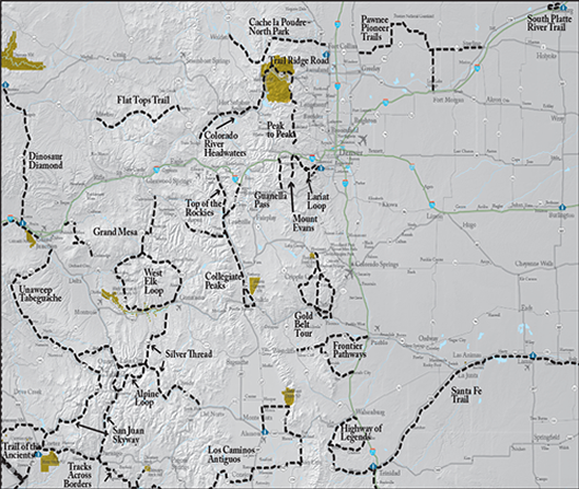
The Colorado Department of Transportation released the interactive map above. You can click on the names of each byway for more details as well best times to travel, and you can get abbreviated descriptions of recommended routes below.
West Elk Loop
The twin summits of Mount Sopris and the incomparable Black Canyon of the Gunnison anchor the ends of the West Elk Loop. Carbondale, Hotchkiss, Crawford, Gunnison, Crested Butte, and other towns offer a slice of Colorado’s rich history, varied lifestyles, and natural fall beauty.
Pawnee Pioneer Trails
This byway traverses the rugged Colorado Piedmont, a wide-open region anchored by the towering Pawnee Buttes. The landscape provides refuge for coyotes, prairie dogs, rattlesnakes, pronghorn antelope, and hundreds of bird species.
Silver Thread Scenic and Historic Byway
The colorful old mining camps of the Silver Thread offer history, scenic beauty, and a heavy dose of authenticity. The heights around Creede and Lake City remain strewn with abandoned mining structures, most of them accessible via rugged back-country roads.
Frontier Pathways
This old frontier zone south of the Arkansas River marked the intersection of Native American, Spanish, French, and American territories. The route spans from Westcliffe east to Pueblo and all the way south to Colorado City.
San Juan Skyway & Unaweep Tabeguache
You start with the major towns along the route — bustling Durango, picturesque Telluride and Victorian jewels Silverton and Ouray. Then you continue to Mesa Verde National Park, home to one of the densest collections of prehistoric ruins in the U.S. and five million acres of undisturbed national forest.
Alpine Loop
The Alpine Loop leaves pavement and people behind, crossing the remote, rugged, spectacular heart of the San Juan Mountains. It’s demanding — the two 12,000-foot passes (Cinnamon and Engineer) require a high-clearance 4-wheel-drive vehicle — but the well-prepared motorist reaps unparalleled rewards: pristine views, hiking and biking, camping and ample solitude.
Peak to Peak
Less than an hour from Denver, Boulder, or Fort Collins, this 55-mile-long route provides matchless views of the Continental Divide and its timbered approaches. There is also a string of popular attractions along the way, including Rocky Mountain National Park, Golden Gate Canyon State Park, Arapaho and Roosevelt National Forests, the Indian Peaks Wilderness Area and Eldora Ski Resort.
Cache la Poudre-North Park
This byway links Fort Collins with verdant North Park, a quiet, bowl-shaped valley just west of the Continental Divide. The road runs through the Cache la Poudre River canyon.
Collegiate Peaks
This paved 57-mile route parallels the Continental Divide at the foot of the Sawatch Range, the highest concentration of 14,000+ foot peaks in the country. The greater part follows the Arkansas River, the most commercially rafted river in the nation, a world-class kayaking destination, and one of the state’s premier trout fishing resources.
Scenic Highway of Legends
From the impenetrable heights of the Sangre de Cristos and Spanish Peaks to the ominous redrock abutments of the Dakota Wall and the Devil’s Stairsteps, this land is truly larger than life. An extension was recently added to the byway from the town of Aguilar on I-25 west over 11,248 ft. The 35-mile extension follows Huerfano/Las Animas County Road #46 through the San Isabel National Forest.
Trail of the Ancients
This 114-mile route across the broken, arid terrain of the former Anasazi civilization is heavily laden with cliff dwellings, rock art and pottery shards. Hovenweep National Monument and Mesa Verde National Park both contain dense clusters of Anasazi remains, and the Anasazi Heritage Center in Dolores offers background and interpretive information.
Gold Belt Tour Scenic and Historic Byway
In the early 1890s the mining towns in the shadow of Pikes Peak enjoyed the greatest gold boom the state has ever known. This 131-mile circuit tours historic Cripple Creek, Florence, McCourt, Adelaide, Wilbur, Victor, and other former gold camps.
Optimal times, events

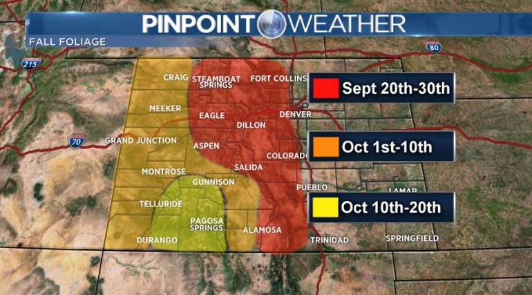
Fall officially arrives on September 22, and peak viewing times for fall color typically last from the third or fourth week of the month through the middle of October.
However, trees could peak early if an unexpected cold snap or high winds happen during this time.