The next generation of geostationary weather satellites is scheduled to launch in October. The GOES-R series of satellites will improve observation and detection of weather phenomenon.
Improved data collection means more timely and accurate forecasts and warnings, which could have a significant impact on protection of property, public safety and economic development.
GOES history
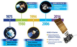
The first Geostationary Operational Environmental Satellites were launched in 1975. Ever since, GOES satellites have delivered continuous imagery and data on atmospheric conditions and solar activity.
Those initial satellites were spin-stabilized, only viewing Earth about 10 percent of the time. They only provided data in two dimensions and gave no indication on cloud thickness, moisture content or any information in the vertical dimension.

The capability to receive vertical profiles was achieved in 1980 when the United States began sending GOES 4-7 series into orbit. The addition of the third dimension gave forecasters the ability to monitor rapidly changing events, help predict fog and flash floods, and better forecast tornadic events.
The next round of GOES satellites (eight to 12) drastically improved the resolution and continuity of the data being received. These advancements were made possible by a few big jumps in technology.
First, instead of being spin-stabilized, the satellites were given three-axis stabilization. Also, the satellites gained the ability to put their normal scans of the hemisphere on hold to focus on a small area. This gave a big boost to short term forecasts and severe weather forecasts.
The latest round of GOES satellites began launching in 2006. GOES 13-15 were equipped with much better batteries and more available power, allowing for continuous imaging.
The series was also given the capability to use geographic landmarks and star locations to assist with navigation to better pinpoint coordinates of intense storms.
GOES-R series
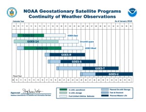
The GOES-R series is the next generation of the GOES family, and will consist of four satellites (16-19). The program is a joint effort with teams from the National Oceanic and Atmospheric Administration and NASA collaborating to develop, deploy, and operate the satellites. The total lifespan of the operation runs through 2036.

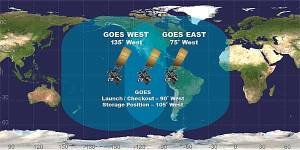
Just as the GOES series operates now, there will be a two satellite system covering the Western Hemisphere. GOES 13 currently operates as GOES East and provides most of the U.S. weather information, while GOES 15 operates as GOES West and covers the Pacific Ocean.

The new fleet of satellites will consist of many valuable tools and upgrades to help with collecting and forecasting of weather and solar data. GOES-R features will include:
- Much improved imager will give 4 times improved resolution, 5 times faster coverage, along with more simultaneous coverage
- Continuous coverage of lightning over land and water
- Better solar/space monitoring imager
- Much higher data rates for Environmental Data Relay
- A magnetometer which will give accurate measurements of the Earth’s magnetic field
GOES-R will provide images of weather patterns and severe storms as frequently as every 30 seconds. This will help meteorologists develop more accurate and reliable weather forecasts and severe weather outlooks.
The project’s environmental data products will support short-term weather forecasts and severe storm watches and warnings, seasonal predictions, drought outlooks and space weather predictions.
Finally, GOES-R products will improve hurricane tracking and intensity forecasts, improve flight route planning, provide data for long-term climate studies, improve solar flare warnings, and enhance space weather monitoring.
