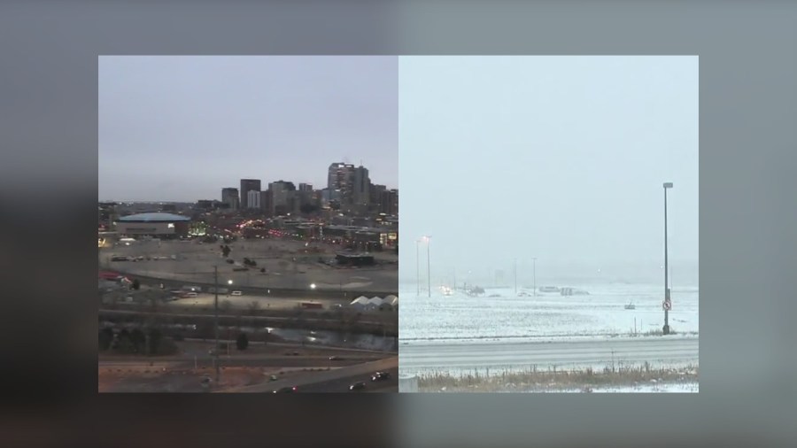
DENVER (KDVR) — Some parts of Denver are seeing snow while other areas of the city remain dry and cloudy. Why is this happening?
Meteorologist Kylie Bearse said it has a lot to do with the downsloping wind.
“It’s when the wind comes from the west or northwest. It travels down the side of the mountain. When it does that, it warms and it dries. That doesn’t make for favorable snow conditions,” Bearse explained.
“We’ve got this low-pressure system that is just off to our east and behind that, on the backside of it, we’ve got these areas of heavy bands of snow. What happens with a system like this is there is a really sharp cutoff. We’re seeing that right on the edge of the metro area, not to mention, we’re fighting with the downsloping winds.”

Downtown Denver saw no snow accumulation on Tuesday morning while Denver International Airport recorded 0.7 of an inch as of 5 a.m., according to the National Weather Service.
Snowfall for Denver is measured at DIA
Since 2008, the NWS has measured snow and temperatures for Denver at Denver International Airport, even though downtown Denver is around 18 miles away from DIA.
What is the forecast?
The Pinpoint Weather team said Denver will see light flurries downtown on Tuesday, but the eastern half of the city could see light accumulations. Highs stay cool in the low 30s with a breezy afternoon wind.
Where to see weather alerts
If a winter alert is issued for your area, whether it is a blizzard watch or warning, winter weather advisory or winter storm warning, it will always show up at the top of the FOX31 website. You can see all weather alerts here.
The Pinpoint Weather team will continue to update the forecast multiple times each day.

