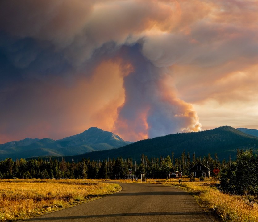
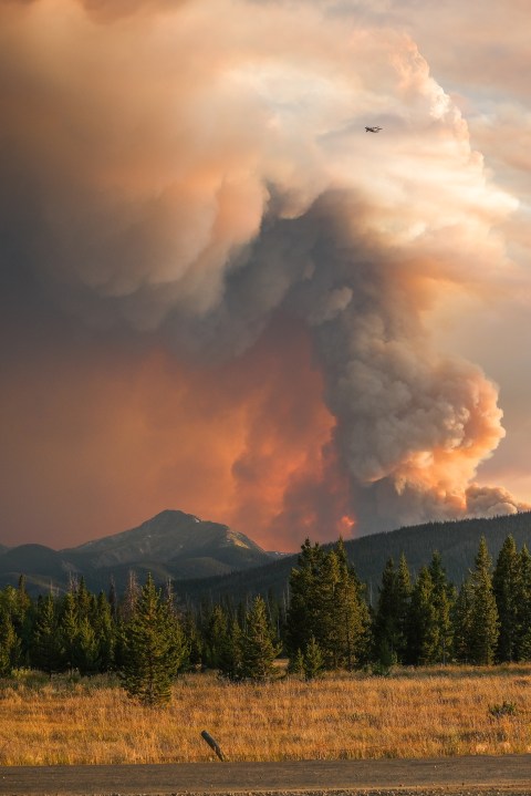
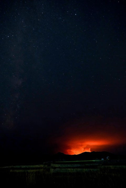
GRAND COUNTY, Colo. (KDVR) — The Williams Fork Fire started Friday, August 14th, in Grand County. As of Wednesday, it had burned more than 14,000 acres. Find the latest updates on the fire below:
Latest updates: Several large wildfires continue to burn across Colorado
UPDATE (Oct. 23, 11:18 a.m.): The Williams Fork Fire currently sits at 14,736 acres with 30% containment. There are 345 fire personnel assigned to fighting the fire.
Yesterday, engines continued to monitor the fire perimeter. Windy conditions limited helicopter operations in the area, but fixed-wing aviation was able to view limited activity and spread throughout the day. As weather and smoke permit, aviation assets will again be available to monitor and support any suppression activities needed throughout the day Friday.
UPDATE (Oct. 8, 6:03 p.m.): A column of smoke could be seen from the Williams Fork Fire today as dry fuels burned in between Richey and Upson Creek on Keyser Ridge.
CR 50 remains closed but Blue Ridge can be accessed from Parshall/Hot Sulphur.
The fire is estimated at 14,091 acres with 25% containment.
Officials have lifted closures on the northern portions of Beaver Creek Road (Forest Service Road 133) and Little Muddy Creek Road (Forest Service Road 134.1). Opening these roads will allow hunters motorized access into the Blue Ridge area north of the fire.
South of Keyser Creek, the existing closure area remains in place. Firefighting activities and active fire behavior continue to be present throughout the entire closure area, including in the St Louis Creek and Elk Creek areas. Forest managers and fire personnel will continue to re-evaluate the closure area as conditions change and firefighting activities wind down.
UPDATE (Sept. 30, 10:55 p.m).: The fire has burned 13,247 acres — an increase of about 400 acres. However, containment has increased significantly, from 14% to 25%.
UPDATE (Sept. 27, 11:08 a.m.): The fire grew to 12,850 acres and is 14% contained. Officials say, “A wind event yesterday over Keyser Ridge pushed the Williams Fork Fire east across Richey Creek into Upson Creek. The fire grew about 300 acres in that area and is now approximately 1.5 miles southwest of Lake Evelyn (FSR 136) and Keyser Creek (FSR 139) roads.”
While cooler temperatures are expected through Tuesday, strong winds and low humidity are expected over the comings days. This could lead to changes in fire behavior.
“A season-ending weather event is needed to put this fire out,” authorities say.
Grand County Sheriff’s Office provided an update:
UPDATE (Sept. 20, 8:05 p.m.): The fire grew slightly to 12,320 acres and the containment is now at 16%.
UPDATE (Sept. 15, 10:54 p.m.): Containment of the fire has increased from 10% to 12%, according to officials.
UPDATE (Sept. 13, 10:48 p.m.): Fire personnel has been reduced by 6 with no growth or additional containment reported on the fire.
Check out the latest interactive closure map:
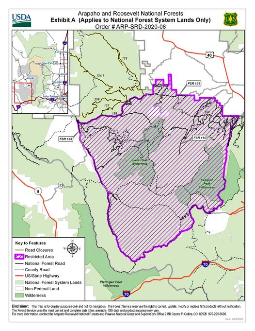
UPDATE (Sept. 13, 4:44 p.m.): Arapaho National Forest managers announced that the closure area will now encompass only lands, roads and trails immediately surrounding the active fire perimeter in the Williams Fork Drainage.
Roads that remain within the fire closure area include: County Road 30, the western half of Keyser Creek Road, Lake Evelyn Road, Keyser Ridge Road, Kinney Creek Road, and Jones Pass Road west of the pass.
Byers Peak Wilderness Area as well as Keyser Ridge Trailhead, Kinney Creek Trailhead, Ute Peak Trailhead, Darling Creek Trailhead, Williams Fork Trailhead and South Fork Trailhead remain in the closure area along with the Sugarloaf, South Fork and Horseshoe Campgrounds.
Officials warn there are still some hot spots within the perimeter plus winds and drier conditions, anyone in the area should watch for rolling debris, falling trees, and landslides.
Grand County experienced strong winds before the snowstorm that rolled in on Monday and Tuesday causing extensive blowdown from the Vasquez Wilderness Area and Berthoud Pass to James Peak Protection Area, Indian Peaks Wilderness Area and the Arapaho National Recreation Area. The district is continuing to survey and assess the damage, which has left some roads and trails impassible. Monarch Lake Loop is currently impassible as is the Hi-Lonesome Trail. Campground managers also have temporarily closed the Big Rock Loop on Arapaho Bay due to downed and hazardous trees.
UPDATE (Sept. 12, 11:11 p.m.): Authorities are working on preserving watersheds around the fire that may have been impacted.
UPDATE (Sept. 12, 11:38 a.m.): A portion of the Arapaho and Roosevelt National Forests are closed to all activities due to the fire. View a full map of the closure area on the US Forest Service’s website.
UPDATE (Sept. 10, 10:48 p.m.): While the unseasonably cold temperatures are moving out of the area, fire weather concerns will remain low Friday.
“Gusty west to northwest winds return Friday in the wake of this departing low, but afternoon humidity expected to remain well above critical areas,” officials said.
UPDATE (Sept. 10, 10:50 a.m.): The Type 2 Rocky Mountain Blue Team will transfer command of the fire to a Type 3 organization tonight at 8 p.m. This is the last daily fire update for the Williams Fork Fire, pending any significant changes. The fire is 10% contained.
UPDATE (Sept. 9, 8:39 p.m.): The number of personnel assigned to the fire shrunk slightly today from 231 to 191.
UPDATE (Sept. 9, 9:41 a.m.): Fire behavior was very light due to the cold front cooling fuels. Snow and colder temperatures continue through the weekend, which will keep fire activity low. Fire managers are preparing to transfer command to a Type 3 organization Thursday evening. Personnel will be reduced as firefighters begin to transfer to other fires.
Today crews will continue monitoring fire activity, helicopter operations will be minimal if any, and firefighters will possibly be working on repair around the edge of the fire.
“The recent snow has greatly reduced fire activity; however, there is a very real chance you will see smoke from within the fire area over the coming weeks as temperatures fluctuate,” Michael Haydon, Incident Commander, said.
UPDATE (Sept. 8, 10:34 p.m.): Rain and snow helped firefighting efforts after a long stretch of hot, dry conditions. Containment remained at 10% in the latest available update.
“Fire managers are closely monitoring fire behavior related to weather changes. Firefighters will be staged to react, as needed, to any changes in fire behavior where it is safe for them to do so,” officials said.
UPDATE (Sept. 8, 10:45 a.m.): Fire activity is expected to be reduced today thanks to the cooler temperatures and precipitation. However this could also mean problems with assistance from helicopters and other air support.
Cold and wind could also impact firefighters on the ground. Crews are keeping a close eye on the weather in addition to the fire to help protect on-scene personnel.
Yesterday, helicopter water drops helped prevent spread to the north and south while firelines were completed by ground crews along St. Louis Creek and Crooked Creek roads.
UPDATE (Sept. 7, 10:38 p.m.): The fire grew slightly to 12,157 acres remaining steady at 10% containment. The number of personnel was reduced from 314 to 268.
UPDATE (Sept. 7, 9:21 a.m.): Fire managers are preparing for increased activity today as a cold front moves in and brings gusty winds. The biggest area of concern is the east side of the fire along Keyser Ridge and possible movement toward the St. Louis Peak area.
Over the weekend, smoke from the Cameron Peak Fire covered the area resulting in lower than expected temperatures.
Because temperatures are expected to drop significantly overnight, all firefighters will be relocated indoors for the night.
UPDATE (Sept. 6, 2:53 p.m.): High temperatures, low humidity and Red Flag Warning wind gusts of 40 mph or more will possibly increase fire activity by drying fuels causing spotting and rapid fire spread.
Helicopters will continue water drops on hot spots while ground crews monitor and rehabilitate contained areas of the fire.
Check out the latest incident map of the Williams Fork Fire.
UPDATE (Sept. 5, 10:57 p.m.): The number of personnel on the fire increased from 289 to 311. No growth of the fire was reported.
UPDATE (Sept. 5, 7:24 p.m.): A FireHawk helicopter went back to work today cooling down hot spots along the northern edge of the fire.
UPDATE (Sept. 5, noon): Over the last two days, crews used drones to monitor heat in remote parts of the fire. Yesterday, helicopters continued to drop water on the northern portion of the fire.
More challenging firefighting conditions are ahead. The National Weather Service has issued a Red Flag Warning.
UPDATE (Sept. 4, 8 a.m.): Fire crews on the Williams Fork Fire have reinforced control lines and cooled down areas with residual heat over the past few days. Heading into the Labor Day weekend, fuels are drying out again; with temperatures rising and relative humidity decreasing, the fire is expected to become more active through Sunday.
UPDATE (Sept. 3, 11 p.m.): Reported fire growth was very small today: just two acres to a total of 12,099. The fire remains 10% contained. Officials say 295 people are currently assigned to fighting it.
UPDATE (Sept. 3, 11:45 a.m.): Drier conditions yesterday allowed crews to mop up the west side of the fire where dragon eggs were used to burn vegetation and create a fire break.
Fire line construction along Crooked Creek Road and St. Louis Cree Road is continuing and will last for several more dayss as crews work to thin the brush and trees in this area.
UPDATE (Sept. 2, 10:57 p.m.): Officials say “critical fire weather” conditions are ahead due to very dry air moving south from Wyoming.
“Low pressure systems riding the northern periphery of this high will cause increased northwest winds that will combine with very dry air and warm temperatures,” officials said.
UPDATE (Sept. 2, 8:50 a.m.): Minimal fire behavior is expected to continue today with pockets of heat and smoldering in the interior of the fire.
Fire crews continue to focus on constructing fire lines west of Fraser along Crooked Creek Road and south along St. Louis Creek Road (FS 160). This work is progressing well; crews expect it will take several days of fuel reduction efforts including tree and brush thinning before these fire lines are complete.
UPDATE (Sept. 1, 10:48 p.m.): Crews are installing fire lines west of Fraser and south along St. Louis Creek Road.
“Although this work is progressing well, crews expect several days of fuel reduction efforts before these fire lines are complete,” officials said.
UPDATE (Sept. 1, 8 a.m.): Cooler temperatures and wet weather persisted over the Williams Fork Fire resulting in no observed fire growth in the past 24 hours.
“Fire activity may increase later this week as a high pressure system is forecasted to move into the area later today bringing warmer and drier conditions,” a statement from the fire management team said.
There are currently no evacuation or pre-evacuation orders in place, but there are some forest closures.
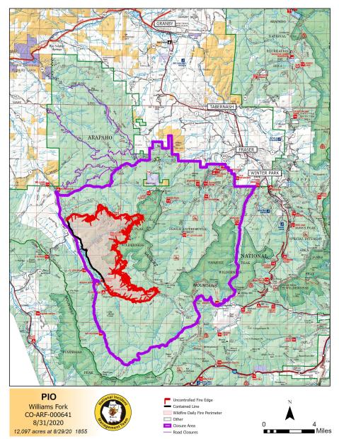
UPDATE (Aug. 31, 11:56 p.m.): The latest map of the fire and surrounding area.
UPDATE (Aug. 31, 1:15 p.m.): The Grand County Office of Emergency Management has lifted pre-evacuation orders for Area 1.
The change comes with a warning that fire and weather conditions could change, forcing the order back into place.
UPDATE (Aug. 31, 9:10 a.m.): Fire managers say that rain over the weekend was varied across the area of the fire but will allow those on the ground to safely make gains on containing the spread.
Fire crews are continuing to build a containment line west of Fraser and south along St. Louis Creek Road, but that work is expected to take several days to complete.
Over the next two days, fire management will transition from the Type 1 Great Basin Team 2 to the Type 2 Rocky Mountain Blue Team.
The management teams are no longer providing daily live updates on Facebook because of the reduction in activity but are prepared to resume doing so if conditions require.
UPDATE (Aug. 30, 10:35 p.m.): There was no update on size or containment for the evening but officials did say that more precipitation on the fire reduced the smoke and helped slow fire activity.
UPDATE (Aug. 30, 7:28 p.m.): The fire is at 12,097 acres and 10% contained. Officials gave an update Sunday evening.
UPDATE (Aug. 29, 7:36 p.m.): Officials provided an update, including a forecast from the fire team’s meteorologist, for Saturday evening.
UPDATE (Aug. 29, 4:42 p.m.): Williams Fork Fire Information Officer Brian Harris provided an update on the fire Saturday afternoon. He says the fire is at 12,079 acres and the sheriff opened up County Road 3. He discusses the burnout area they just completed and as they finish mopping up the area, that will become contained.
UPDATE (Aug. 29, 9:12 a.m.): Pre-evacuation notices have been lifted. They were in place for the following areas: Aspen Canyon, Morgan Gulch and Henderson.
UPDATE (Aug. 28, 10:47 p.m.): Officials described fire activity during the last few days as “moderate.” Structure protection in the Fraser Experimental Forest is now complete.
UPDATE (Aug. 28, 1:07 p.m.): Watch Doreen Summerlin, Lead Resource Advisor, explain what Resource Advisors are doing.
UPDATE (Aug. 28, 7:37 a.m.): The fire grew to 12,048 acres overnight and remains 5% contained.
Officials reported that the overall fire activity and growth remained moderate as crews continued mop up activities near the burn area on the southwest portion of the fire. They said some hot spots along the burn area remain, but containment of the fire in this location is anticipated within the next several days.
UPDATE (Aug. 27, 11:54 p.m.): With firefighters reaching containment on the southern flanks of the fire, heavy equipment will move east to construct containment lines around private land and the Fraser Experimental Forest.
“Firefighters have worked around Denver Water Supply structures and the Bobtail Mine to thin vegetation and set up sprinklers that can help defend structures if the need arises for them,” officials said.
UPDATE (Aug. 27, 9:18 a.m.): Fire managers say that moderate weather on Wednesday allowed firefighters to make progress toward adding containment measures around the fire.
Additional heavy equipment arrived to help construct a fire line west of Fraser near the Beaver Mountain and Moose Run subdivisions. This work will take several days.
Near the Williams Fork River along Route 30, crews are working to mop up after burning operations were completed earlier this week. This includes looking for hot spots and ensuring the fire line will hold if winds pick up in that direction.
There are currently no evacuations in the Fraser Valley, but a smoke advisory is in place and several forest areas are closed to visitors.
UPDATE (Aug. 27, 4:30 a.m.): The Grand County Incident Management Team is planning evacuation scenarios.
UPDATE (Aug. 26, 11:38 p.m.): The number of personnel fighting the fire has increased from 310 to 344.
UPDATE (Aug. 26, 2:40 p.m.): Firefighters at the Williams Fork Fire are taking to the air to help fight the wildfire with fire.
In an update from this afternoon, fire managers talked about how they have helicopters that are equipped to drop small spheres, similar to ping pong balls, into an area for a controlled burn.
These spheres contain a mixture of chemicals that react and ignite after a short delay.
“This type of ignition allows for burning or firing operations in terrain that may be difficult or unsafe for firefighters to reach by ground,” the update said.
UPDATE (Aug. 26, 8 a.m.): The fire grew 500 acres on Wednesday morning to 11,726 acres with 5% containment.
Fire managers expect more containment over the next few days after they completed a burn operation east of County Road 30.
To the north, crews are working on a containment line between nearby communities.
A live video chat with fire managers will take place at 5 p.m. tonight on the Williams Fork Fire Facebook page.
UPDATE (Aug. 25, 11:04 p.m.): While acreage and containment estimates remain unchanged tonight, the number of people fighting the fire has increased slightly to 310.
UPDATE (Aug. 25, 8 a.m.): The fire grew to 11,266 acres with 5% containment on Tuesday morning.
UPDATE (Aug. 25, 4:40 a.m.): The Thornton Fire Department’s E-108 crew has been protecting 2 homesteads and a bat sanctuary #williamsforkfire . The homestead they are assigned to is over 140 years old, with 15 cabins and multiple out bldgs. The family that homesteaded the land still owns and uses it.
UPDATE (Aug. 24, 9:00 p.m.): Officials provided a daily update via Zoom on Facebook.
UPDATE (Aug. 24, 7:26 a.m.): The fire grew to 11,048 acres with 3% containment Monday morning.
Firefighters made good progress on Sunday, preparing additional line to the west and southwest portions of the fire. These efforts will be used as control lines for providing future containment. Burning vegetation between the line and the main perimeter of the fire will be accomplished during favorable weather conditions and will provide a secure line of containment. The burning operations may occur on Monday or Tuesday if conditions allow.
UPDATE (Aug. 24, 4:26 a.m.): The fire grew to 10, 813 acres over the weekend with 3% containment.
UPDATE (Aug. 23, 8:17 p.m.): Grand County Sheriff Brett Schroetlin provides an update for the community.
UPDATE (Aug. 23, 3:47 p.m.): Latest update from officials.
UPDATE (Aug. 23, 2:20 p.m.): Despite increasing temperatures, the Williams Fork Fire experienced minor growth on Saturday, as other weather conditions allowed for only moderate fire activity. It is now burning 10,813 acres with 3% containment.
There are no evacuation orders for residential areas in the Fraser Valley.
UPDATE (Aug. 22, 9:05 p.m.): Check out photos of efforts to contain the fire today.
UPDATE (Aug. 22, 4:44 p.m.): Authorities are investigating the cause of the Williams Fork Fire. Their fire investigation team is asking the public for help in gathering information about the start of the fire.
If anyone was in the Williams Fork area the night of August 13 or morning of August 14 and has any photos of the area where the fire started, please email them to SM.FS.usfsarp@usda.gov. If you have other information to share, you can call 307-745-2392, option 5, and leave your name and call back number so law enforcement can contact you.
UPDATE (Aug. 22, 3:55 p.m.): Smoke has settled into the communities of Parshall and Kremmling this morning bringing unhealthy conditions. There will be some improvement to USG for those communities this afternoon. Moderate smoke conditions will prevail over the remaining communities further away from the fire. For more information click link below https://wildlandfiresmoke.net/outlooks/CentralColoradoFrontRange
Check out video of a helicopter drop:
UPDATE (Aug. 21, 8:46 p.m.): Video footage of the fire burning on Thursday shows fire behavior on the southwestern flank near County Road 30, as well as firefighters setting up sprinklers for structure protection.
UPDATE: (Aug. 21, 5:34 p.m.): During a streamed update on Facebook, Williams Fork Fire incident commanders said the fire had only grown by about 100 acres in the past 24 hours, and it’s possible more assistance will arrive over the weekend.
The biggest concern, they said, is Bottle Pass where winds and a lot of fuel could cause rapid spread. Because of this they are considering options to clear the pass or put fire retardant down in the area.
At this point the fire remains about seven miles southwest of Fraser. The town is still considered safe and is not in a pre-evacuation zone.
There’s expected to be a lot of smoke in the area of the fire in the morning, but as winds pick up throughout the day it should clear out.
The hope is to have the southwest flank contained next week.
UPDATE: (Aug. 21, 9:26 a.m.): Fire managers said today’s goal is a continuation of structure protection along with improving the fire line on the west and southeast areas of the fire.
UPDATE: (Aug. 21, 7:18 a.m.): The fire grew to 10,288 acres with 3% containment on Friday morning.
A Forest Service closure area is in effect that includes Forest Service road that access that closure area. Fire managers ask the public to remain outside of the closure area so they can focus their efforts on fire suppression and not be hindered by unauthorized access.
UPDATE: (Aug. 20, 10:24 p.m.): Officials say the fire did not have significant growth today. Fraser and Winter Park remain about 7 miles from the blaze. Hotter and drier weather is expected over the weekend.
UPDATE: (Aug. 20, 4:15 p.m.): Heavy smoke from the Williams Fork and Cameron Peak fires is causing potentially dangerous air quality conditions along the Front Range.
SkyFOX flew to Fort Collins this afternoon, but because of the conditions had to turn around and return back to the airport.
UPDATE (Aug. 20, 7:45 a.m.): The fire grew from 6,726 acres to 9,457 acres on Thursday morning due to strong winds, low humidity.
UPDATE (Aug. 19, 8:44 p.m.): Some rain fell in the area today. Officials say the containment “toehold” is near the town of Fraser, which is good news.
UPDATE (Aug. 19, 7:40 a.m.): The fire has grown slightly to 6,726 from 6,600 acres on Tuesday night.
According to incident Commander Tony DeMasters, today’s firefighting efforts will focus in protecting infrastructure and high resource values in the area.
Fire managers are developing contingency plans with an overall goal of preventing the fire from reaching private lands.
UPDATE (Aug. 19, 7:02 a.m.): The fire is now 3 percent contained, according to an update from a spokesperson on the scene of the fire.
UPDATE (Aug. 19, 4:50 a.m.): FOX31/Channel 2 reporter Nicole Fierro will provide updates on the fire on TV starting at 5:30 a.m.
UPDATE (Aug. 18, 11:32 p.m.): The Southwest Area Incident Management Team #3 has assumed control of firefighting operations. Officials say using air tankers to establish retardant lines has been effective in slowing the fire’s spread.
UPDATE (Aug. 18, 5:57 p.m.): Fire managers report that the fire was active today, fueled mostly by trees killed several years ago during the beetle infestation in the area.
As one of the manager said, “there’s a long way to go, but we’re feeling pretty good.”
The good news, as was mentioned during an evening news conference, is that the topography of the area and the slope aren’t conducive to a large burn. That’s good news for Winter Park and Fraser.
UPDATE (Aug. 18, 10:13 a.m.): The Williams Fork Fire remains active but did not grow in size due to northwest winds, according to the Southwest Incident Management Team on Tuesday morning. The fire remains at 6,627 acres in size and is still 0% contained. No evacuation orders have been issued.
UPDATE (Aug. 17, 10:52 p.m.): Monday evening incident update has the fire burning 6,627 acres moving in an easterly direction toward Lake Evelyn in the Byers Creek Wilderness.
UPDATE (Aug. 17, 5:30 p.m.): In a Facebook live update, officials working to contain the Williams Fork Fire said the winds have been favorable in preventing the spread of the fire toward Winter Park and Fraser.
The fire is still considered active, but officials said it hasn’t spread much in any direction today. The fire has been “cleaning up” and destroying brush in the area where it has burned.
Grand County is also planning to put out plans for possible pre-evacuations. At this time there are no pre-evacuations, but the county said it wants to give residents as much time as possible.
Click here for updates from Grand County.
UPDATE (Aug. 17, 2:45 p.m.): In an update on the Williams Fork Fire Info Facebook page, organizers said the northwest winds have been helpful in containing the fire.
Crews are working to prevent the fire from spreading across highway 30 at this time.
UPDATE (Aug, 17, 1:30 p.m.): FOX31’s Nicole Fierro is in Grand County talking to residents and first responders about the fire. According to fire officials there are 120 team members on the ground and a Type 1 Team, the highest level response team, is on its way to assist.
Fire officials in Grand County are planning to provide an update at 5 p.m. You can watch that live in the FOX31 News App.
UPDATE (Aug. 17, 9:40 a.m.): The fire has grown slightly overnight to 6,345 acres but according to crews is still at 0% containment.
At this time, the fire appears to be human caused, but more details have not been released.
UPDATE (Aug. 16, 8:34 p.m.): No residential areas in the Fraser Valley are being evacuated at this time, but authorities are preparing residents in case. Grand County’s Be Wildfire Ready has many useful tips for how to prepare for evacuations.
UPDATE (Aug. 16, 7:03 p.m.): The fire is now at 6,336 acres and growing, according to the RMA Predictive Services.
UPDATE (Aug. 16, 4:15 p.m.): As of Sunday afternoon, the Forest Service reports the fire is at 6,000 acres. Fire made its way into Darling Creek and just starting burn into Byers Peak wilderness to the east. Forest closure orders are in effect west of Winter Park and Fraser, including Vasquez Creek, St. Louis Creek; Church Park.
UPDATE (Aug. 15, 10:18 p.m): The Williams Fork Fire grew in multiple directions throughout the day with shifting winds. The fire expanded north toward Keyser Creek and south toward the Sugarloaf burn scar overnight, increasing in size to at least 4,300 acres. The fire is burning in a remote area that experienced intensive beetle kill in the early 2000s and is being fueled by extremely dry conditions and winds.
UPDATE (Aug. 15, 5:42 p.m.): The US Forest Service reports the fire has burned approximately 4,145 acres and is actively burning to the south. The fire is 0% contained.
UPDATE (Aug. 15, 5:35 p.m.): The Grand County Sheriff’s Office and Grand County Office of Emergency Management provided an update via Facebook Live.
UPDATE (Aug. 15, 3:58 p.m.): The Grand County Office of Emergency Management sent out a CodeRED PRE-evacuation notification for the Aspen Canyon, Morgan Gulch, and Henderson area.
UPDATE (Aug. 15, 1:46 p.m.): The U.S. Forest Service says fire activity is expected to increase through the afternoon.
The Grand County Sheriff’s Office plans to hold an update via its Facebook page at 5 p.m.
UPDATE (Aug. 15, 9:12 a.m.): Officials say the fire has reached the top of Kinney Creek and Darling Creek.
“Henderson Mill and its infrastructure along with multiple other utilities are in the immediate area,” the Forest Service said in an online update.
An evacuation and information center has been established at the The Inn at Silvercreek Conference Center in Granby.
UPDATE (Aug. 14, 9:52 p.m.): According to the US Forest Service, the fire has now burned 1,300 acres. It is 0% contained.
UPDATE (Aug. 14, 7:41 p.m.): Pre-evacuation notices have been issued for the following areas: County Road 50, 50S and St. Louis Creek Road (County Road 73).
“Today is August 14, 2020. The Williams Fork Fire has grown recently and the Incident Commanders and Sheriff have issued this pre-evacuation order to provide you time to prepare your home and belongings in the event that an evacuation is ordered. Please have all necessary items ready to go should the order to evacuate be given. Please do not call 911 unless you have an emergency,” officials said in an online update.
UPDATE (Aug. 14, 7 p.m.): The Grand County Sheriff’s Office has issued mandatory evacuation orders for homes in the immediate vicinity of the fire, not including the Fraser Valley.
“The fire is in a remote area of the upper Williams Fork Valley and is growing to the east towards Church Park. Take an overnight bag with necessary items such as regular medications, change of clothes, identification, cash, water, snacks. Don’t forget your pets and their food, bowls, and meds,” the sheriff’s office said in a statement.
Earlier Friday, Grand County Emergency Management issued mandatory evacuations on County Road 30: Sugarloaf Campground and South Fork Campground and road closures of County Roads 3 and 30.
UPDATE (Aug. 14, 6:42 p.m.): Officials say the fire has grown to 823 acres.
UPDATE (Aug. 14, 4:30 p.m.): Additional road closures have been announced as the Williams Fork Fire is expanding and now burning over 250 acres.
Grand County Sheriff’s Office and Hot Sulphur Springs Fire are responding to a wildland fire on CR30, south of Williams Fork Reservoir.
Per the sheriff, this is Forest Service land near Henderson Mill. Heavy air support has been ordered.
Updates will be posted as they are received.
