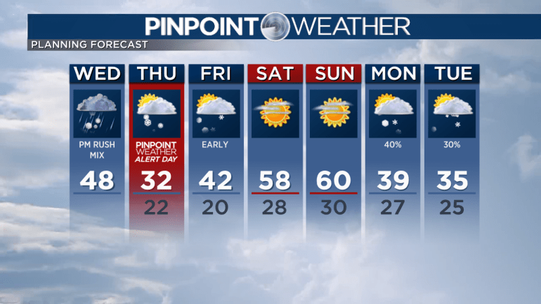
DENVER — Wednesday will start dry before a light wintry mix and light snow move into the Denver metro for the afternoon commute.
The mountains can expect 2-6 inches of snow Wednesday above 8,000 feet. Some valley rain is possible. This is the warmer of two storm systems moving into Colorado.
The second colder storm system arrives overnight through Thursday with another 2-6 inches of snow accumulation possible.
Snow trickles into Friday morning with another 1-2 inches of accumulation. That puts mountain grand totals between 6-14 inches.
Across the Front Range, temperatures stay below freezing Thursday with areas of light snow primarily for the evening commute into early Friday. There will be 1 inch of snow accumulation.
As a result, a Pinpoint Weather Alert Day for Thursday has been issued. With colder temperatures, it will be possible for snow to stick to the roads.

It will be drier Friday afternoon through Sunday. Weekend highs reach 60 degrees.
Next week will be stormy and colder.
The first of two storm systems arrives Monday with snow for Denver and the mountains. It might continue early Tuesday.
Another storm system with snow will be possible around Thanksgiving.

Check Colorado interactive radar and zoom in to where you are. Plus, check the radar anytime with the Pinpoint Weather App for iPhone and Android.
Pinpoint Weather has been independently certified as Colorado’s Most Accurate Forecast by WeatheRate.
We’re tracking Denver weather today on FOX31 and Channel 2 News – and when conditions are bad we send out the Weather Beast.

