DENVER — A strong cold front is making its way south through eastern Colorado Saturday evening. As it moves through, winds will pick up, temperatures will drop significantly, and rain and snow will develop.
Snowfall is expected to arrive in metro Denver around midnight and will continue through Sunday afternoon. Snow showers will be heaviest late Saturday night and early Sunday morning.
Roads could be slick and slushy in some spots on Sunday, so allow extra time to get to where you need to be.
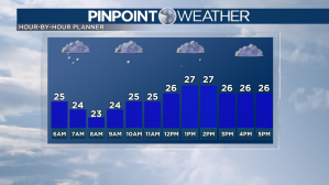
High temperatures will only make it to 27 degrees in Denver. Be sure to bundle up if you have outdoor plans such as the Broncos game.

Snowfall will taper off from north to south tomorrow afternoon and evening, ending in southern Colorado late Sunday night.
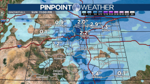
The highest totals will be in the northeast mountains, where 3 to 8 inches of accumulation are possible. The Front Range will pick up 2 to 5 inches with 1 to 3 inches on the eastern Plains.

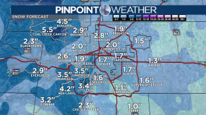
Most spots east of Interstate 25 in metro Denver will see totals around 1 to 3 inches. The west and south sides of town will see 2 to 5 inches with 3 to 6 inches possible in Boulder County.

Denver and the Front Range will dry out for the rest of the week. Temperatures will reach the 40s on Monday and will warm to the 60s by Wednesday.
Check interactive radar and zoom in to where you are. Plus, check the radar anytime with the Pinpoint Weather App for iPhone and Android.

Pinpoint Weather has been independently certified as Colorado’s Most Accurate Forecast by WeatheRate.
We’re tracking weather today on FOX31 Denver and Channel 2 News – and when conditions are bad we send out the Weather Beast.

